There are a few streets in the Heatherington neighbourhood I still hadn’t travelled down, so that’s where I biked to on Saturday morning. But first I had to go to the theatre for a meeting, and then to Fabricland on Walkley Road to buy a whole lot of canvas.
The Heatherington neighbourhood has seen troubled times, such as this guns and ammo seizure in August. However I have always felt very safe biking through the neighbourhood.
A lot of the houses are similar to these ones on Heatherington Avenue.
There’s this sprawling electric transformer depot.
And there are these great murals covering all four sides of a small service building in the centre of Fairlea Park.
I caught wind of a new memorial unveiled along Island Park Drive near the Ottawa River so I decided to go have a look. But first I had to shop at Fabricland on Merivale.
It was rush hour and rainy so I chose the route with least traffic. That’s how I wound up biking down Arthur Lane.
Arthur Lane & Fairview Towers
Years ago I photographed images of Fairview Towers from this location and projected them as part of the set design for a play called A Number (three middle images on the right).
A Number
They’ve since added the barbed wire to the top of the chain link fence separating Arthur Lane from the Towers parking lot. I’m glad I found myself re-visiting this alley, as they are in the process of remodelling the building.
After stopping off at Fabricland I worked my way over to the new memorial. It’s visually impressive. I included my trusty steed in the first shot to provide a sense of scale. The second image is probably how the designer would prefer it be viewed.
Memorial
There were no interpretive elements on site to explain the intended meaning of the monument, or it’s actual name, however from various news stories (here, here, and here), it seems it’s main purpose is to commemorate diplomats who have lost their lives in the call of duty. This particular site was chosen because the first assassination of a diplomat on Canadian soil occurred close by on Island Park Drive.
This evening I biked off towards Britannia Bay via the Voyageurs Pathway on the Gatineau side of the river.
Pont Champlain as seen from the Voyageurs Pathway
I covered a few streets within the triangle defined by the Ottawa River Pathway, Richmond Road and Britannia Park. Many of the houses in this area were of this faux exposed timber design.
OK, I’m cheating a bit on this post. Carla and I drove to the amazing Fieldwork art installations site over the weekend for their 5th year anniversary barn dance. HOWEVER I did bike there when we first visited the site earlier this summer. Here’s the route I took.
Now the reason I’m cheating is because this art phenomenon is worth breaking a few rules for.
The images below are just some of the installations presently on display throughout the field and adjacent woods. The photos don’t do the works justice, as these sculptures are very much influenced by the surrounding natural environment in which they are located, and how one discovers them while progressing through the varied landscape. Definitely worth a visit.
The Osgoode Township Museum and Historical Society, located in the old town of Vernon (now part of Ottawa), had their Fall Harvest Festival this past Saturday. I needed to shop at The Wood Source out that way, and I really wanted to travel the last stretch of the Osgoode Trail, so early that morning I saddled up and headed off. The Wood Source is conveniently located right beside the Osgoode Trail, so after ordering my lumber (delivery included – phew!) that’s where I headed.
First splash of Fall colours
I followed the trail all the way to the old town of Osgoode (now part of Ottawa too), where the weathered textured surface of this house on Main Street caught my eye.
Weathered house in Osgoode
Osgoode was originally settled in 1854 as suggested by this sign I noticed on the way out. I look forward to re-visiting this old town.
Settled • Établi 1854
There were a couple of fields along 2nd line road that were completely clear of any growth. The only thing that broke the surface were fresh hoove prints such as these, suggesting deer had recently passed through, some running, others walking.
Flat field
A whole bunch of Coroplast signs along this stretch made it look like a hotly contested election campaign was under way! Upon closer inspection, I remembered these types of signs are also used to announce genetically modified crops.
GMO fields
Fourth Line and McDiarmid are gravel roads.
Gravel
One spot along McDiarmid Road had sheep on one side, cows on the other.
Sheep, cows. Cows, sheep.
On the way into Vernon this weathered house caught my eye.
House in Vernon
The Fall Harvest Fair was very intimate. While waiting for Carla and Nick to join me by car I paid a visit to their museum, which was full of interesting artifacts. For example, this is but one of a series of hair wreaths that were on display. A popular Victorian custom, these wreaths were often made from hair of the deceased.
Hair Wreath
When Carla and Nick arrived we sat at one of the pic-nic tables and had apple cider, corn on the cob and pumpkin pie while listening to these two fine musicians on the fiddle and accordion. Lousy photo, sorry. They played a great take on Dirty Old Town. Here is The Pogues version, almost as good.
Pic-nic Music
Then we headed over to the enormous hanger next to the museum that is a filled with old farming equipment. One could spend a whole day in here. Thank you Vernon, it was lots of fun.
Google maps shows a bike trail starting off on the east side of Riverside Drive, just south of Rivergate Way. When I got there this evening it was blocked by a locked gate, the chain link fence kind. The paved trail was further obstructed by a fallen tree about 10 yards beyond. I had noticed a small uncharted path a bit further north along Riverside Drive, so I followed that instead, anticipating it would eventually lead me to the blocked off trail.
Path up from Riverside Drive
This was an unmarked mystery path, which looked alot like this most of the way.
Path
Eventually it did become wider, confirming my instincts I was on the right scent. I had just passed another bicyclist who was out with his dog when disaster struck. A stick got caught in my derailleur and busted it right off, like so.
I carried my bike to the corner of Uplands and Country Club Drive, sent a drop pin to my super partner Carla, and waited to be picked up.
While waiting I sent a photo of the damage to Mike, my bike-whizz-bro-in-law, asking if he thought the repair was within my skill set, or whether I should ask a pro. Regardless, I am desperate to get back in the saddle. “sigh….”
As I was plotting this morning’s ride on Google Maps, I discovered a trail between Merivale and Woodroffe that isn’t shown on my trusted MapArt paper map. Hmmm… adventure awaited!
I accessed the mystery trail from Glenmanor Drive, just beyond Merivale Road. This is the view that greeted me.
Giants!… no, hydro towers…. phew!
The unmarked path is open in some parts like this….
Fields
In other areas it is surrounded by tall shrubbery, like this….
Shrubbery
With dozens of un marked access points along the way, I felt like I had entered an overgrown hedge maze. My instincts told me to continue along the path most trodden, which eventually led me out to this glorious view.
Wow
A bit beyond was Woodroffe Avenue, from the edge of which I turned and snapped this last shot. All very exciting.
Excellent choice of street names (roughly translated as Cycling Street and Outdoors Activity Street). So early this morning I biked off to Gatineau to check them out.
But first, the moon. Here it is hovering way above the Chinatown arch.
The moon above
Another beautiful view en route was to be had here along the Ruisseau de la Brasserie.
Ruisseau de la Brasserie
With a bit of imagination, the metal half round chimney top detail on many of the houses in the Rue du Cyclisme / Rue du Plein Air area might be considered a post-modern reference to a bicycle wheel.
Po-mo chimney detail
However I think the names are more in reference to their proximity to Gatineau Park and the many bike paths easily accessed from these streets. I took the path past Leamy Lake on the way home, which looked like this as I biked by.
Yesterday was one of a number of household hazardous waste drop off days hosted by the city throughout the year. This time it was at BFI landfill site on Navan Road. I’ve been wanting to dispose of an old can of paint, so I bundled it up in a garbage bag, stuffed it into one of my panniers, and headed off.
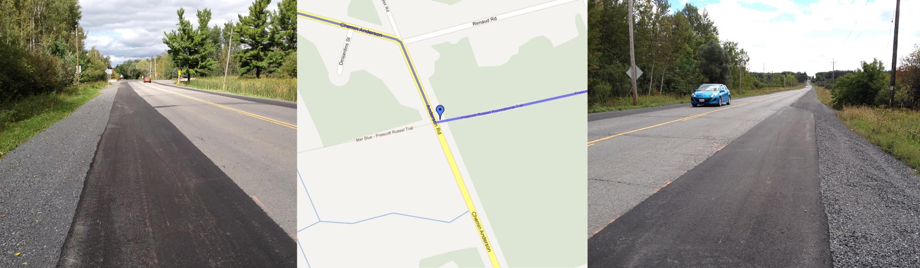
Part of the route took me a short distance along the Prescott-Russell Recreational Trail. This amazing trail runs along the old VIA Rail line almost all the way to the Quebec border. Working your way through the city to the trailhead is a bit tricky, especially choosing the safest way to get across the 417. Cyrville Road isn’t terribly bike friendly, but I find it a lot safer than crossing at Innes Road. There are dedicated bike lanes along Innes on the east side of the 417. They have also added paved shoulders along Anderson Road as far as the trail head, like so:
Mmmmm…. paved shoulders
Here’s the trail.
Prescott – Russell Trail
The images below show both sides of Navan Road taken from the same spot just beyond Renaud Road.
Barn & Houses
Not much to see as I biked in to the BFI land fill site. I suppose that’s in everyone’s best interest, as long as the waste is safely disposed of. I’m guessing the big pit on this Google satellite image is the landfill.
BFI Waste Management Site
The hand off went very smoothly. They asked for my postal code, took my paint, and away I went.
On my return trip I decided to bike along Navan Road to access the area of Blackburn Hamlet. Navan Road was awful (no shoulders, crumbling asphalt, speeding cars). Blackburn Hamlet was great. You’ll notice on the map how the bike path weaves its way through a narrow strip of parkland. The residential properties back right up to the path, providing rapid scenarios of folks enjoying their Sunday afternoon. Here’s what it looks like at one of its wider spots.
Path through Blackburn Hamlet
I then joined the Greenbelt Trail. As I biked into the toboggan hill parking lot where it crosses the path, I surprised a couple as they rushed to pull up their pants and jump in their car. Awkward. A bit further on, the path wove through a great big field of tenacious wild flowers holding on through the dying days of summer.
Wild Flowers
The Ottawa River Pathway was filled with folks enjoying a Sunday promenade. I watched sailboats ply the river while small planes flew low overhead, taking off at regular intervals from the nearby Rockliffe airport.
Boats and Planes
On the way through Rockliffe I discovered this nice little trail across a wooded park that took me up and over to the driveway.
Today I biked west along the Ottawa River Pathway and circled back under the Queensway to cover a few streets in the Graham Park part of town.
A little further east there’s a narrow strip of commercial spaces along Morrison Drive and Iris Street between the Queensway and residential housing areas. Some have been there for quite some time, like the original Lee Valley Tools.
Lee Valley Tools
There are also some shared commercial spaces like this one, headquarters to a new successful company hi-lited in this Citizen article.
Shared Commercial Space
The Citizen itself is just a bit further east, beyond the giant Ikea, which was my destination.