An Ottawa bike tour of designs by architect Francis Sullivan

A number of interesting buildings around town were designed by Francis Sullivan, an adherent/colleague/disciple of the famous American architect Frank Lloyd Wright and the Prairie School of architecture. The following bike route visits a number of Sullivan’s surviving works within Ottawa. This ride is approximately 14km long.

.
Our tour begins in Rockcliffe Park at 108 Acacia Avenue where sits this grand old house, one of Sullivan’s early designs upon his return from working with Frank Lloyd Wright in 1907. The Prairie School aesthetic is not as evident in the exterior detailing of this majestic home as they are in Sullivan’s subsequent designs.

108 Acacia Avenue
108 Acacia Avenue

Next stop – The Francis Sullivan House in Sandy Hill at 346 Somerset St E.

n 1911 Sullivan started up his own successful independent practice from which he designed this home for himself in 1914. Here the influence of the modernist Prairie School style is on full display.

Sullivan House - 346 Somerset Street E.
Sullivan House – 346 Somerset Street E.

To get to our next stop I rode up Somerset, through the Ottawa U campus, and over the pedestrian/bike bridge across the canal. I then pedaled along the Rideau Canal Western Pathway in the direction away from Parliament Hill as far as Patterson Creek, crossed Queen Elizabeth Drive and followed the creek to our next destination, the O’Connor St Bridge. Another example of his early works (1907), It’s a solid looking little bridge that has withstood the test of time.

O'Connor St Bridge
O’Connor St Bridge

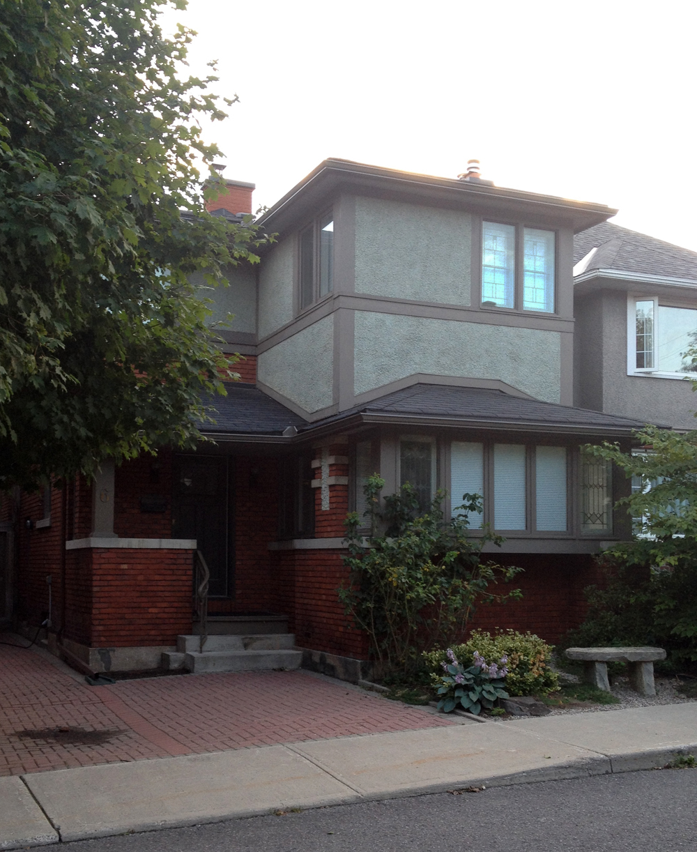
A short distance up Patterson Creek at 6 Allan Place sits the following Sullivan house design.

6 Allan Place
6 Allan Place

Our next Sullivan building is located at the corner of James and Bay. To get there I rode over to Percy St which has traffic lights and a bike lane to help cyclists ride safely under the Queensway and across busy Chamberlain and Catherine Streets. I rode over to Bay St which is a one way heading north WITH a bike lane, that brought me right to the Patrick J. Powers House. It was originally built around 1887 but transformed by Sullivan in 1915 in to the beauty that it is now.

Patrick J. Powers House - 178 James Street
Patrick J. Powers House – 178 James Street

Over to Arthur St where once stood the No. 7 Fire Station which Sullivan designed in 1912. The exterior has been greatly modified since the mid-1960s when it was acquired by the Bukowinian Greek Orthodox Holy Trinity Church, as per a land and property transfer described in this Urbsite post. Only a few of Sullivan’s details remain, most notably the corners of the building. The rest have been smothered or altered.

No 7 Fire Station (drastically modified) - Arthur Street
No 7 Fire Station (drastically modified) – Arthur Street

The final two buildings are located on roads just off Wellington St, a busy street I consider to be one of Ottawa’s most dangerous stretches to ride down resulting in the constant threat of cyclists being doored or squeezed off the road by impatient drivers. The sharrows painted on the road (bike logos with two chevrons) are meaningless to most drivers and ignored. I avoided Wellington by following the route described on the above map, which includes carrying my bike down the stairs at the end of Primrose ave to the bottom of Nanny Goat cliff.

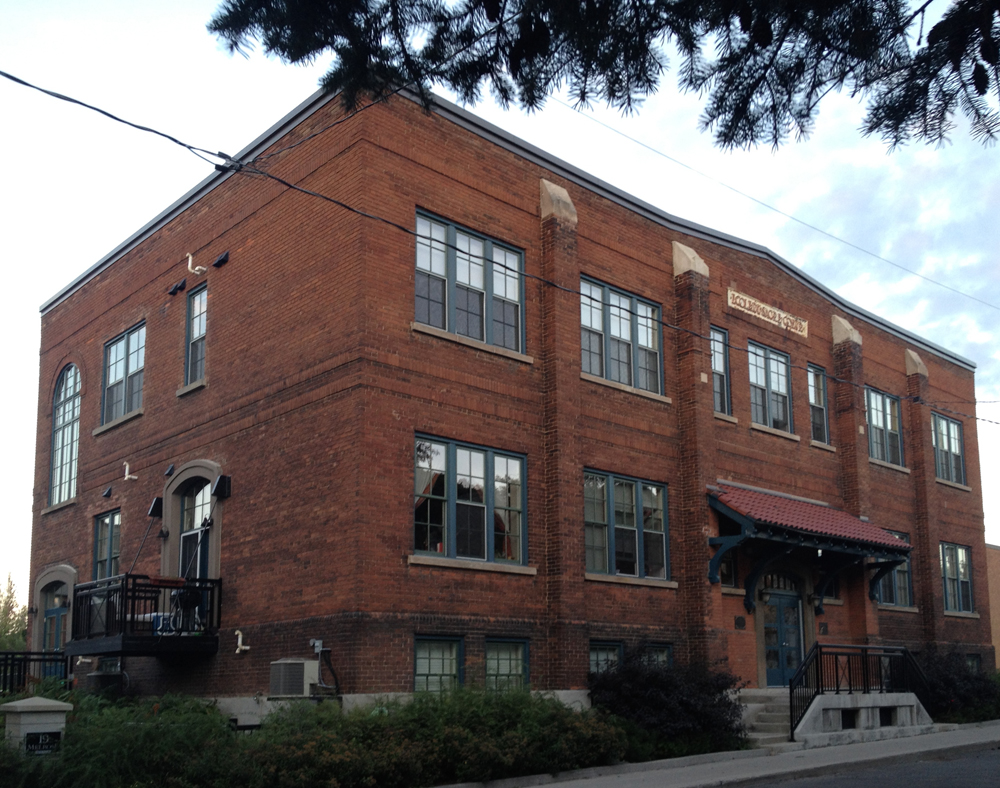
Next destination is École Sacré-Cœur at 19 Melrose Avenue in Hintonburg, which is no longer a school, but a residence, as one of the residents explained to me as I was taking the photo below.

École Sacré-Cœur - 19 Melrose Avenue
École Sacré-Cœur – 19 Melrose Avenue

Final stop – the Edward P. Connors House at 166 Huron Ave North. Some wonderful Prairie Style detailing and proportions to be seen in this example as well.

Edward P. Connors House - 166 Huron Ave N
Edward P. Connors House – 166 Huron Ave N

So there you have it. Thank you Francis Sullivan!

Getting to Blue Skies 2014… an alternative

by François Dumas

My first glimpse of the main stage at Blue Skies 2014

Like Brian, I have been going to Blue Skies for two years; actually I met Brian there last year when he had biked his way to the festival. I’m a bike tourer myself so this was the cue I needed to try it out this year.

I usually plan my routes the old-fashioned way, I use Google Maps. Now there is one geographical obstacle to biking to the Blue Skies festival in Clarendon and that is Mississippi Lake starting at Carleton Place. It means you either go north or south of the lake. I chose the north route while Brian took the south route to get to the festival.

Not wanting to rush the full 116 km ride in one day, I tapped into what I believe is the greatest thing about bicycle touring, the bicycle touring community. And the best tool around has got to be the web site warmshowers.org. Their web site showed me that there were two members in Lanark, north of Mississippi Lake so I let Mr. Google plot my route through that town.

I could tell by the squiggly lines on Google Map that this would involve small dirt roads around some uneven terrain. This is the Hastings Highlands after all. Here is a map of my route: https://goo.gl/maps/0Zyqq

A welcome break In Carleton Place as the rain clouds dispersed over the falls.
This is a fish story... I swear I saw this huge Blue Heron flying away from this creek on Concession Road 3A. I should have photoshopped it in because it was a turning moment for me as the countryside re-aligned my city soul.
This is a fish story… I swear I saw this huge Blue Heron flying away from this creek on Concession Road 3A. I should have photoshopped it in because it was a turning moment for me as the countryside re-aligned my city soul.

So, same Trans-Canada Trail from Ottawa to Carleton Place as Brian but I then headed north across Bridge St. which becomes a dirt road called Quarry Rd. I was now deep into Ontario backcountry on a beautiful sunny day. Concession roads 4A, Old Perth Rd, Concession road 3A led to Wolf Grove, a fast-paced paved road that had me yearning to get off asap onto the next turn. Purdy Rd. was that road and that quickly became Rosetta Rd., turning from pavement back to gravel and an equally slower pace with fewer cars. That brought me right into Lanark when I crossed the Clyde River. A good first day and a delightful evening with my hosts there.

Next day’s journey was relatively simple as far as navigation was concerned; I had to follow route 12, also called Macdonald’s Corners Rd., turn on Robertsville Rd. right down to Clarendon Rd. where the festival was. Turns out I took a wrong turn (natch!) and ended up on Clarendon quicker than I anticipated. Clarendon Rd. is a country lane that turns, climbs and weaves through lush small remote farms; just a gorgeous ride. The slower pace meant I also got pursued relentlessly by deer files. It turned out to be a game of tag where the swarm caught up with me on the climb and my losing them down these inclines; a welcome relief.

Tip the Clown at Blue Skies 2014
Tip the Clown, one of the many colourful characters I had the pleasure to meet.

When I started seeing temporary “No Parking” signs along the gravel road, I knew Blues Skies was just around the bend.

I would do that same route again next year. I still prefer splitting the 116 km route into two days. It’s beautiful country roads and backwoods Ontario nature and it really is a hop and a jump from Ottawa. Let’s get a group together next year and make it a trip, shall we?

Biking to Blue Skies Music Festival from Ottawa – Route #2

The Blue Skies Music Festival near Clarendon, Ontario takes place on the first weekend of August, as it has every year since the early 70’s. It’s a great big gathering where folks come for a day, or camp out over the 3 day long weekend.

This year was the third time I’ve been. Last year I biked to a friend’s cottage close by on Sharbot Lake, then rode up to the site on the following Friday morning. You can read all about that adventure here. This year I did the same, however I chose a different route, identified by the blue line on the map below.

I rode back to Ottawa on the following Monday along the red line shown on the map, similar to the route my friend François rode to get there this year, which you can read about by clicking here.

.

Last year’s ride took me much longer than I had anticipated, so this year I tried to streamline my route to shorten the time spent in the saddle. To get out of Ottawa I headed straight down Wellington/Richmond/Robertson Road. Now most cyclists familiar with that stretch of road might not consider it the safest option. Few sections of it are safe most hours of the day, however there is a narrow window of opportunity early in the morning before traffic starts to build. I left the house at 5:30 am. Things went smoothly, until Richmond turned in to Robertson Road, just west of Baseline. That’s where any semblance of a paved shoulder disappears and the surprising number of cars, buses & trucks that early in the day flew by at highway speeds. I was very relieved to get on the Trans-Canada Trail west of Moodie Drive.

Calm & minimal traffic along Richmond....but narrow & speedy traffic along Robertson Rd
Calm & minimal traffic along Richmond….but narrow road & speedy traffic along Robertson Rd

The Trans-Canada Trail between Bells Corners and Carleton Place is an old railway line that has been converted to a packed stone dust path, as described in a bit more detail in the middle of this post. I’ve travelled it a few times now, so in search of a little variety, and to speed things up, I rode along Abbott Street for a short stretch through Stittsville, which runs parallel to the Trans-Canada Trail. Traffic was calm, and there was a generous shoulder for most of it’s length.

Packed stone dust Trans-Can Trail....& paved shoulder along Abbott Street through Stittsville
Packed stone dust Trans-Can Trail….& paved shoulder along Abbott Street through Stittsville

Stittsville went through a growth period in the 1870’s when the railway line connecting Ottawa to Carleton Place was introduced. There are a few surviving examples of buildings from that period near the intersection of Main and Abbott Street where the train station was located, including this fixer upper sandwiched between the Trans-Canada Trail and Abbott St.

Old house in Stittsville

The rail-to-trail section of the path ends on the edge of Carleton Place. From there I headed south-east along a path that runs parallel to McNeely Ave to where it crosses Highway 7. At the end of McNeely there is a wonderful network of short trails called the Beckwith Trail, that meanders through a varied mix of wooded area and old farmland. I followed the McGregor Branch and the Shady Branch to get to 9th Line road.

Sections of the Beckwith Trail

I then headed southwest along 9th Line, a two lane road where I encountered minimal traffic. Saw some beautiful big old brick farm houses. I also road through a thunderstorm. I passed this family of bovines just as the rain let up, staring at me as if to say, ‘What the heck are you doing way out here in this weather?!’

Befuddled bovines
Befuddled bovines

9th Line turned into Tennyson Road which I followed for a bit before turning on to Concession Road 7. It too was a nice quiet paved two laner through farm country. On the other side of the 511 it became a very smooth white stone dust road.

White stone dust surface along Concession Line 7

Road 7 morphed into McVeigh road, which I followed to where it ended at Doran Road. Now Doran Road was the trickiest stretch along this year’s ride to Blue Skies. It narrowed down to one lane with a loose stone gravel surfacing that went up and down through the woods for quite a ways.

Loose gravel along Doran Road

The road surface became smoother once it turned on to Fagan Lake Road, and then paved once more on the other side of the Elphin-Maberly Road, along Zealand Road.

I am always amazed by the cedar post fences that weave their way through this whole area. The manner in which they are stacked and arranged in a zig-zag pattern allows for great flexibility in negotiating the rough rocky terrain. Here’s an example, perched up on the edge of a stone cut along Zealand Road.

Cedar post fence
Cedar post fence

For the rest of the ride I followed Bell Line Road and the A&P trail to my friends cottage on Sharbot Lake, and then up to the festival site the following morning, as described at the tail end of last year’s post.

Et voila – ’twas another wonderful Blue Skies festival full of music galore!

Early morning mist rising on a farmers field near Clarendon