Biking to Sundae School on Beechwood for some yummy ice cream!

Sundae School is a brand new ice cream parlour on Beechwood Avenue. A couple of Chinatown residents are in need of a bike commute route to get there. The rest of us need a consume route because the ice cream is super delicious!

The blue line on the following map is the route Carla and I rode to get there. The short purple line is a slight variations heading back.

UPDATE – Summer 2018: Sundae School moved a couple of blocks south along Beechwood, on the west side of the street. Their new location is indicated on the map. Bike lanes have also since been added along Beechwood from when this route was originally posted, as indicated by the green line on the map below.

We begin at the corner of Primrose and Empress, right in front of the Dominican University College.

Dominican University College at the corner of Primrose and Empress

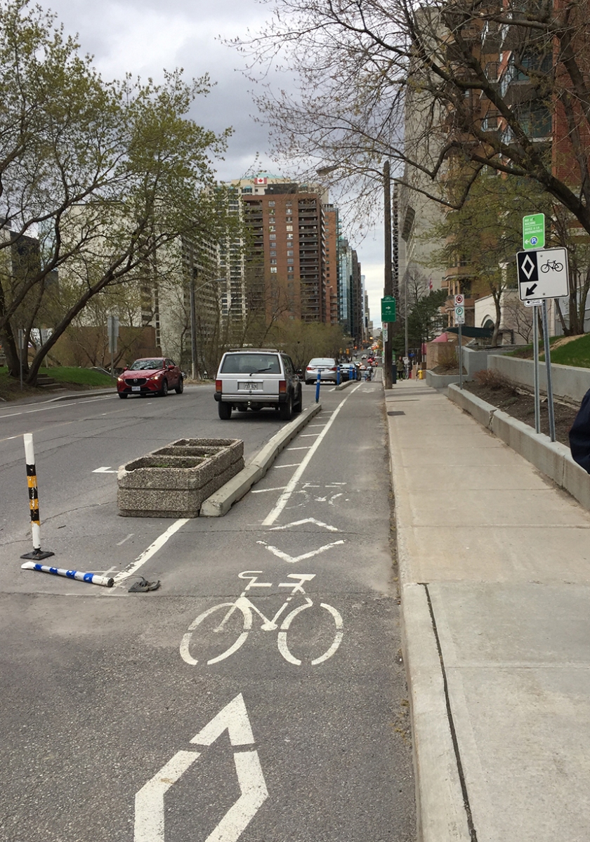
We rode east along quiet Primrose Avenue, then turned left on to Cambridge St North. This took us to Laurier Street. The segregated bike lane along Laurier starts on the other side of Bronson Avenue. We followed the Laurier Bike Lane all the way to City Hall.

Start of Laurier Bike Lane at Bronson

We then turned off Laurier at the exit ramp just before heading over the bridge, which took us down to Queen Elizabeth Drive. There isn’t a bike lane along the short exit ramp, but the lane is quite wide. That said, some do feel safer taking to the very wide sidewalk, while others cut through Marion Dewar Plaza infront of City Hall to Queen Elizabeth Drive to avoid having to ride along the exit ramp. If I was taking kids for an ice cream outing I would do the same. There are three way stop signs to facilitate cyclists and pedestrians wanting to cross Queen Elizabeth Drive to get on to the Rideau Canal Western pathway.

Riding along the Rideau Canal Western Pathway

Ww rode over the Rideau Canal via the Corktown Bridge.

Up and over the Rideau Canal along the Corktown Bridge

We crossed Nicholas Street at the lights and rode through the Ottawa U campus to King Edward Avenue. After crossing King Edward we sailed down Somerset East all the way to the Adawe bike & pedestrian bridge. This section of Somerset has a potpourri of vanishing and re-appearing painted bike lanes. It usually has lots of other cyclists too, as it serves as a well travelled bike link between the two non-car bridges.

Crossing the Adawe Bridge

Once over the Adawe Bridge we turned north along the Rideau River Eastern Pathway.

Rideau Rideau River Eastern Pathway

The pathway crosses Montreal Road. Many drivers tend to be extra antsy and aggressive at this intersection. Advance cross lights for pedestrians and cyclists would be helpful.

Crossing Montreal Road heading north along the Rideau River Pathway

We continued along the pathway, eventually arriving at St Patrick St where we could have turned up onto Beechwood but chose not to. That’s because the section along Beechwood for a couple of blocks immediately north of the river is attrocious for biking – very tight space with parked cars offering lots of dooring potential, and impatient drivers roaring up behind you on adrenaline rushes after flying along the St Patrick Street speedway. UPDATE- Fall 2017: This has all changed! as mentioned in the intro, there are now bike lanes along Beechwood (see green line on the above map). That said, the original route described below is still legit.  We continued along the Rideau River Pathway under St Patrick before turning onto a short gravel path that took us to Crichton Street.

Path continuing under St Patrick St
Gravel path off Rideau River Pathway to Crichton St

We rode east half a block along Crichton to get to Vaughan Street – a quiet residential street heading north.

Vaughan St

This brings you to Putman Avenue. Their new 2018 location is at the corner of Putnam and Beechwood.

Sundae School (in their original 2017 location) !
Yummy!

Once we had finished our well deserved treat (I highly reccomend the chocolate flavour) it was time to head back.

The only variation on the route back was getting from the Rideau Canal Pathway to the segregated section of the Laurier Bike Lane that starts west of Elgin street. To get to the inersection of Laurier and Elgin we rode under the Laurier Bridge, then cut through Confederation Park.

Et voila!

Biking to the Costco in Gloucester from Overbrook

Having viewed a previous post on biking to the Costco in Gatineau, a resident of Overbrook was wondering if there was a similar bike route to the Costco off Innes Road. Bike lanes have recently been introduced along Cyrville Road creating huge improvements for cyclists trying to get to destinations south-east of the Queensway/401 highway split, such as the Costco in question. The following route includes the new lanes along Cyrville, pointing out a few challenging spots along its trajectory.

The Adawe bridge spans the Rideau River from Strathcona Park in Sandy Hill and touches down on the opposite shore of the Rideau River at the westernmost tip of Overbrook – a fine spot to begin our adventure.

I turned right and headed south along the Rideau River Pathway for a short distance before turning inland at the little green sign pointing towards Queen Mary Street.

Looking out over the Rideau River from the Adawe bridge…. and where to go once on the eastern shore.
Exit off Rideau River Pathway towards North River Road

I then turned right along quiet North River Road, then left onto Presland Road West.

Turn from North River Road onto Presland Road West

An extensively upgraded pedestrian and cycle crossing has been introduced to help traverse busy Vanier Parkway, connecting the two sections of Presland Road.

Approach to the Vanier Parkway crossing bike from Presland Road West

I continued along Presland, a residential street  which morphs into Hardy Street for a couple of blocks at the eastern end. I turned right off Hardy onto a short bike path link to a bidirectional bike path that runs along Coventry Road.

Link from Hardy to Coventry Road
Bidirectional path along Conventry Road

The path ends a short distance east at the lights crossing over to the St Laurent Shopping Centre. A bike lane then continues on the opposite side heading east. Things get a little hairy as the bike lane crosses a long extended merging lane onto St Laurent Boulevard.

Coventry Road bike lane approaching St Laurent Blvd

Once across St Laurent the path continues along busy Ogilvie Road which I followed for a short distance before turning right onto Cyrville Road.

Ogilvie Road and CyrvilleRoad intersection
Beginning of bike lane along Cyrville Road

Cyrville road once cut through the village of Cyrville, the centre of a farming community that supplied the Byward Market with bountiful produce. It gradually succumbed to a series of amalgamations and the land was taken over by heavy industries. You may notice lingering hints of the old community of Cyrville when passing through, the most predominate being the Notre-Dames De Lourdes church.

Notre-Dames De Lourdes church

The bike lane continues up and over the 417 for the first of two occaisions then, just beyond Labrie, it veers away from the edge of the road to become it’s own seggregated lane – always welcome.

Bike lane veering right slightly to become a segregated lane, just beyond Labrie Ave.

The lane eventually snuggles up to the road once again, then gets a little narrower as it passes over the 417 for a second time before easing off again once on the other side. Be aware of a telephone support cable stuck in to the centre of the path just before heading over the 417 again, particularly if you are pulling a trailer. I managed to squeeze my Wike trailer to the right away from traffic.

Crossing the 417, take 2: Telephone pole support cable…. and path narowing heading over bridge

The least pleasant stretch of Cyrville Road is the approach to Innes Road. After sharing space with a turning lane into the Home Depot parking, the painted bike lane then shares a long curved exit lane as it approaches Innes. Innes is as a multi-lane major road artery that leads to on/off ramps to the 417, so traffic can be pretty frenetic heading through this intersection.

Start of long curve heading towards Innes Road

The bike lane dissapears beyond the Innes road intersection requiring one to ride in traffic for 10 yards or so before turning in to the Costco parking lot.

View across Innes towards turn in to Costco parking

The bike rack is near the south west corner of the building so I stayed to the right while heading around the building, avoiding the usual route cars take, which is to head to the left upon driving on to the lot.

Bike rack

Leaving the site requires carefully negotiating with cars funneling through the same exit. Most are well behaved while leaving the lot as there is often a police officer guiding traffic.

I headed back the way I came with very similar conditions on the return route.

Et voila!

Biking to the Ottawa Train Station from Centretown

The Ottawa Train Station is located a few kilometers outside of downtown. Here is a bike route to get there from Centretown.

I started off from the intersection of Laurier & Bronson avenues and headed east along the Laurier Bike Lane.

Laurier Bike lane starting at Bronson Ave
Laurier Bike Lane starting at Bronson Avenue

After passing in front of City Hall I took the exit towards Queen Elizabeth Drive and got on to the Rideau Canal Western Pathway.

UPDATE – July 2018: They’ve installed bi-directional multi-use lanes on the sidewalk just after you exit off Laurier. 

Exit ramp off Laurier just beyond City Hall
Crossing Queen Elizabeth Drive to the Rideau Canal Western Pathway

I rode south along the Rideau Canal Western Pathway before crossing the canal over the Corktown bridge.

Up and over the Corktown Bridge

I traversed Colonel By Drive at the pedestrian lights and rode under the Nicholas Street tunnel, then up through the University of Ottawa campus.

Crossing Colonel By Drive towards the tunnel under Nicholas Street

After crossing King Edward Avenue at the traffic lights I rode straight down Somerset East before heading up and over the Rideau River on the Adawe Bridge.

Heading down Somerset Street East
Riding over the Adawe Bridge

On the opposite side of the river I turned right onto the Rideau River Easten Pathway.

Rideau River Easten Pathway

Just after riding under the Queensway along the Rideau River Easten Pathway I turned left onto a packed gravel path that leads to the intersection of Riverside Drive and Tremblay Road.

Gravel path off the Rideau River Eastern Pathway

Crossing the Riverside Drive and Tremblay Road intersection is the least pleasant spot along this route. Something about Riverside Drive seems to compel drivers to become impatient speedsters. The oncoming left lane is also a Queensway off ramp with a yield sign to compel drivers to let you cross. There used to be a path that went over Riverside Drive, thus avoiding this intersection, but it is blocked off (temporarily I hope) as the new transit line is being constructed.

Approach to Riverside Drive and Tremblay Road intersection
Crossing Riverside Drive and Tremblay Road intersection

Once through the intersection I continued along the sidewalk that runs parallel to Tremblay before it becomes a paved path leading up to the train station.

Path along Tremblay up to the train station

I passed all the taxis lining the circular approach to the front of the station to get to where there is a bike rack just to the left of the main doors. This location, along with the security camera hanging right above it, provides me with the confidence to leave my bike locked up to the rack when I go away on a train trip for a few days. It’s a huge improvement from a long time ago when the only option was to lock your bike to a post near the poorly lit car parking lot. That’s where I discovered my bike was stolen after returning from a weekend trip to Montreal. The bike rack out front is much better.

Bike parking at the train station

On the way back I retraced my route, except for the section along Laurier in front of City Hall. That’s because when heading west along the Laurier Bike Lane, the safe segregated section only starts at Elgin and Laurier. To get there I cut through Confederation Park as indicated by the purple line on the above map.

If anyone needs a bike route to the station from another area of town, send me a starting reference point by email or via the ‘Leave a comment’ tag.