Starting to winter bike in the National Capital Region

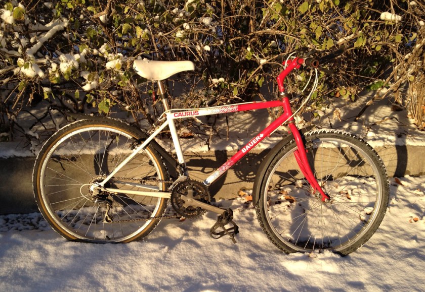
I was as happy as a kid when I awoke to see this season’s first serious layer of freshly fallen snow. It meant I could officially launch my recently acquired winter bike – this handsome red model purchased from Re-Cycles on Bronson. For the last couple of weeks it’s been prepped and all set to go.

Winter bike

I was not disappointed – I love it. It’s a slower-as-she-goes ride (heavier bike, wider tires with studs on the front, snow & ice, etc) than on my summer bike, but great for getting around in our wintry climes.

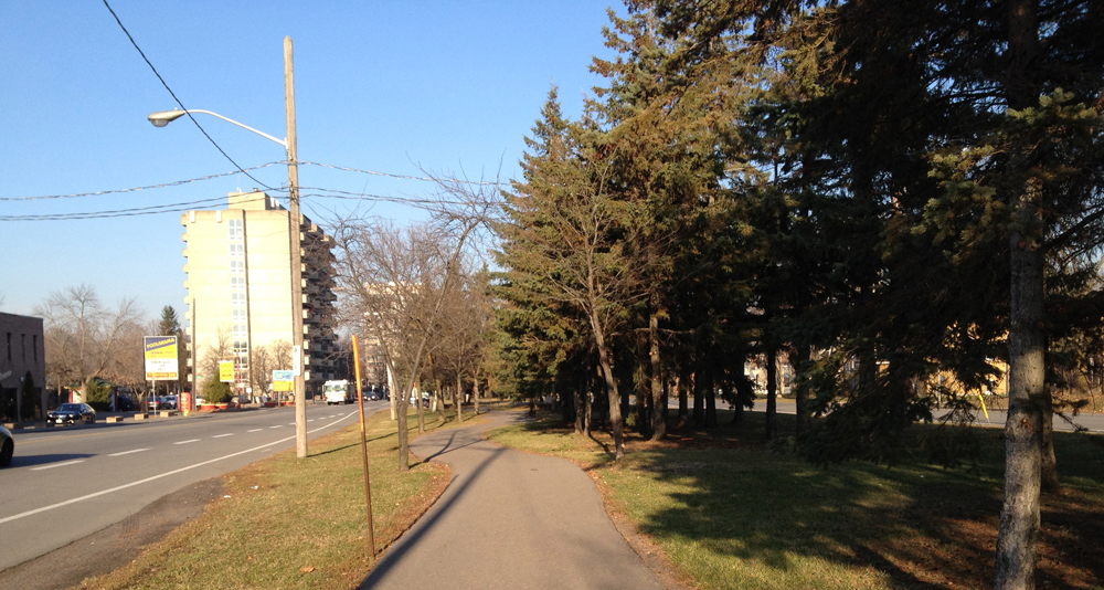
Here’s a short route to get things going which I followed after walking my son to school. Somerset between Bronson and Preston is pretty tight even on a snowless day. This is my favourite way of getting around it.

at the eastern end of the Somerset O-train bridge there’s a little road that curls under and pops out near the old commercial area called City Centre. UPDATE – Dec 2014 : The O-train bike path has since opened and this season it’s being cleared of snow, offering an alternative to having to using the mini-underpass with trucks and cars. The orange line on the above map is the suggested O-train path detour.

Somerset mini-underpass

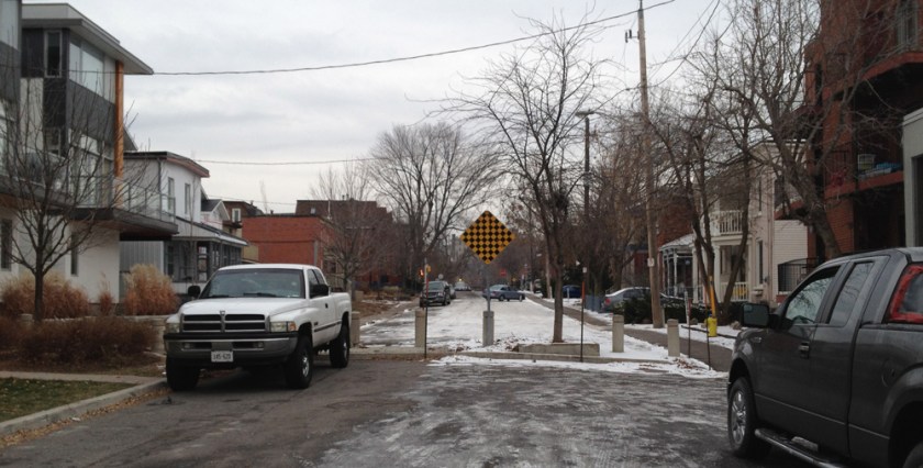
Elm Street a couple of blocks down is a quiet street. That’s because it’s blocked off to cars half way to Preston. But not to bikes.

Half way down Elm Street

Preston has a cross walk signal, as does Booth when you get to it. Very nice.

A bit up Primrose you come face to face with Nanny Goat Hill (or cliff). The flight of stairs is very manageable if you don’t mind carrying your bike a bit.

Stairs up Nanny Goat Hill

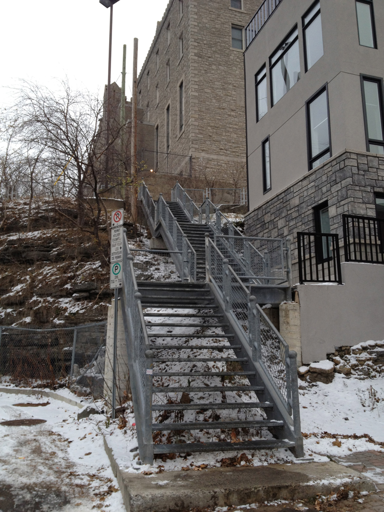
At the top of the stairs there is a cleared path that goes the rest of the way up to where Primrose continues on.

Primrose path

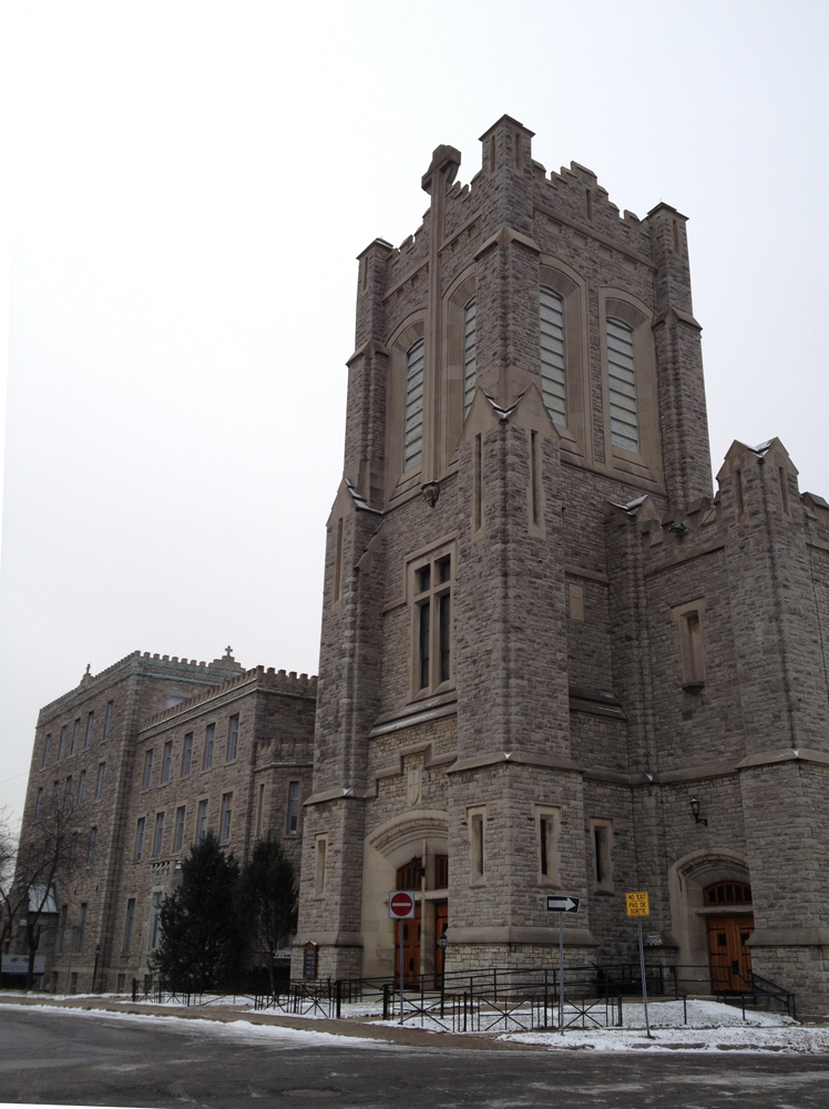
Going this way allows for a good close look at Dominican University College, which was built in 1899 as a Dominican convent, and continues to function as a Monastery as well as a college. This is where the guys in brown robes walking along Somerset hang out.

Dominican University College

UPDATE – January 2015: I am now riding a single speed bike with narrower tires on a 20+ year old steel frame. Changed bikes because in cold weather the pawls on the rear hub (little ratchets that allow you to freely pedal backwards) on my previous multi-speed bike would occasionally freeze and not allow me to pedal forward. Bought the wheel at MEC, the single speed sprocket and studded front tire at Tall Trees, and assembled the whole bike at Re-Cycles.

Picturesque Ruins at the Mackenzie King Estate

While composing the last post I was reminded of Prime Minister Mackenzie King who collected a number of old ruins and selectively placed them throughout his property in the Gatineau Hills. So I decided to bike up and pay them a visit.

It was the first time I had taken advantage of the Gatineau Parkway being closed to traffic for the season, and it was fantastic. Lots of folks walking, jogging, biking, out having a great time. The Parkway is closed to cars north of the visitor parking indicated by the P on the following map.

.
Here’s a map showing where the various ruins are located up at the estate which is open to the public.

Map of MKE showing where to find the ruins

1) The first is this bay window on the edge of the woods.

ruin #1

2) A bit further along stands this majestic arch. Love it.

Arch

3) On the crest of a little hill sits an assemblage of architectural details Mackenzie King named the Abbey Ruins. Here are the various pieces that make up the Abbey Ruin.

Abbey Ruins

I end this entry with a shot of the trail through the woods between the Abbey Ruins and the Mackenzie King Estate parking lot.

Chunks of Old Buildings

Over the course of my local velo adventures I’ve happened upon a number of old architectural ruins selectively placed throughout the city. On Saturday I re-visited three of them. Here’s how the grand tour panned out.

The first, located behind the Royal Ottawa Mental Health Centre, is this handsome entrance to what was once the E.C. Whitney Building. I can’t find a description of the original building, or who E.C. Whitney was, however there was a successful general manager of a wood mill in the township of South Algonquin community of Whitney by that name who appeared on the scene way back in 1895.

What’s left of the E.C. Whitney Building

Next stop brought me to the edge of the Rideau River near Bank St where this commemorative wall is located. It is constructed of stones that formed part of a blacksmith’s fireplace dating back to 1814, which was disassembled in 1960 to make room for road construction. Two interpretive plaques are mounted on the wall, one facing the bike path which includes a rendering of the original fireplace. The other plaque is attached to the other side, and describes Braddish Billings on whose estate the blacksmith shop was situated.

Commemorative wall

The last bunch of ruins on this tour can be found in Rockcliffe Park just east of Acacia Avenue. They are my favorite.

This fountain is actually a faux ruin. It was designed by the sculptor René Bertrand Bouté 1912 to look like one. But who’s splitting hairs? I love it.

Soper’s Fountain in Rockcliffe Park

These columns come from the Carnegie Public Library, which was located at the corner of Laurier and Metcalfe from 1906 to the early 1970’s.

Carnegie columns

I think this tumbled column and the scattered capitals near the fountain come from the same building.

Tumbled columns and scattered capitals

This variation of a Corinthian capital, located away from the other ruins near Acacia Avenue, reminds me of the sad legend describing how this architectural order came to be. I’ve included Vitruvius‘ telling of the story below the photo.

Corinthian capital

“Now the first invention of that capital is related to have happened thus. A girl, a native of Corinth, already of age to be married, was attacked by disease and died. After her funeral, the goblets which delighted her when living, were put together in a basket by her nurse, carried to the monument, and placed on the top. That they might remain longer, exposed as they were to the weather, she covered the basket with a tile. As it happened the basket was placed upon the root of an acanthus. Meanwhile about spring time, the root of the acanthus, being pressed down in the middle by the weight, put forth leaves and shoots. The shoots grew up the sides of the basket, and, being pressed down at the angles by the force of the weight of the tile, were compelled to form the curves of volutes at the extreme parts. then Callimachus, who for the elegance and refinement of his marble carving was nick-named catatechnos by the Athenians, was passing the monument, perceived the basket and the young leaves growing up. Pleased with the style and novelty of the grouping, he made columns for the Corinthians on this model and fixed the proportions. thence he distributed the details of the Corinthian order throughout the work.”

The spirit of the Colonel lives on!

Years ago a friend and I drove to Vancouver, then down the west coast as far as Tijuana, and back home to Montreal across the midwestern states, which is how we wound up in Corbin Kentucky. That’s right, the birthplace of Kentucky Fried Chicken! Although I’d only sampled KFC’s finger lickin’ goodness once or twice before, we couldn’t just drive past without checking it out. Expecting a glorified shrine of sorts (we had just visited Graceland) I was pleasantly surprised at how low key and homey they had kept Harland Sanders original wood clad restaurant, like so:

KFC’s birthplace in Corbin, Kentucky.

As this interpretive plaque explains, Harland tried various careers with little success before catching his groove cooking chicken, and the rest is history.

The Colonel’s story cast in bronze.

Now of course KFC is a gargantuan fast food enterprise, but in one of its transitional phases from monstrous to gargantuan, it unloaded many of it’s trademark outlets that looked like this.

Older KFC outlet

Over the course of my local bike ride adventures I’ve noticed three outlets have been converted into small, one off restaurants, just like the Colonel’s first digs so many years ago. SO, I decided to visit all three, with a couple of extra stops along the way.

First stop, Ottawa U’s Academic Hall. Built in 1901, it is the oldest theatre in the National Capital Region.

Academic Hall

On my way to the first ex-KFC, I paused to photo this panorama from the centre of Parc Jules Morin. This is also Angel Square, popularized by Brian Doyle in his story of the same name, and adapted to the stage by Jan Irwin.

Angel Square

Casa do Churrasco, at the corner of St Andrew and Dalhousie, once served up yummy Portuguese food. Unfortunately it didn’t survive. In its KFC conversion they removed the big bucket sign but kept the sign post to use as a planter holder.

Casa do Churrasco

I headed down the path behind Majors Hill Park, but someone left all the canal locks open, except the top most one near Sappers Bridge. Usually one of the two lower ones are closed, providing access to the other side. No problem. It just meant climbing all the way up to the top of the locks, affording me this wonderful view back down to the river.

Canal locks

Next stop: Hintonburger. Lots has been written about this new kid on the block. They haven’t even taken down the big bucket yet. (Update, August 6, 2013 – They took the bucket down).

Hintonburger!

My final ex-KFC destination was Mia’s Indian Cuisine further west on Richmond Road near Woodroffe. Richmond hasn’t much of a shoulder on the north side to ride on and traffic can be pretty speedy in this area so I followed the winding path straddling Richmond and Byron.

Winding path between Richmond and Byron

Samsu Mia is a refugee from Bangladesh. His story, and how he and his family managed to start up Mia’s Indian Cuisine restaurant in another converted KFC outlet, can be found in this CBC report by clicking here. There’s even a bonus photo of the original KFC included in the article to compare to how it looks now.

Mia’s

I ordered a couple of vegetable samosa’s and onion bhaji from the take out menu to share with Carla and the kids. It’s all I could fit in my handle bar bag.

Interior of Mia’s

So there you go. Two out of three successful Kentucky Fried Phoenixes risen from their ashes!

Return to Stony Swamp

The last time I biked through the Greenbelt Stony Swamp Sector, many of the trails were closed due to wildfires in the area during this summer’s prolonged dry spell. I promised myself I would return once some of the trails were re-opened, so today I did. The blue line on the map is the route I followed to get there. Red line is how I got back.

I joined the Greenbelt trail network after crossing over highway 416. The ecological diversity in this area is remarkable.


Along the section of trail between Highway 416 and Moodie Drive I noticed this old stone pit someone had recently used to have a campfire.

Stone pit

I followed Moodie Drive to get to the trails west of Moodie. This wide gravel shoulder wasn’t too bad for the short distance I had to travel.

Moodie Drive

Just beyond the trailhead sits this wild bird care centre.

wild bird care centre

There are a couple of board walks along the trail that look out onto beaver ponds. This particular spot must be popular for feeding chickadees. I had only to pause for a moment before these bold little guys were all around me.


Incoming!

I happened upon lots of people holding out their hands onto which the birds would land, pluck a seed and then fly off.

Unfortunately not ALL the trails are open yet. I guess they are still cleaning up after the fire.

Trail closed

On the way back I biked through the residential area called Bells Corners East which appears to have been built up in the 50’s and 60’s. This house has retained much of it’s original detailing. I’ve seen similar big stars on houses through out the country, particularly in New Brunswick. They may symbolise something in particular, like the star in the Acadian flag, or they may also be a popular detail from the period. Not sure.

House

I then wound my way home along the Ottawa River.

Ahhh…..

Biking west on a windy day to Ikea

Monday I had to bike to Ikea. Strong westerly winds made me hesitate. The challenge was to find a route that avoided speedy traffic AND Aeolus. Success! The blue line shows how I got there, red is how I got back. The short pink lines are where I could have gone to avoid the wind just a little bit more.

First, head towards the Experimental Farm Pathway via Dow’s Lake and Prince of Wales Drive. UPDATE 2019: If you are getting to Dow’s Lake via the O-Train path there is a detour under the Queensway while they do major construction on the overpass. This safe  detour is indicated on the map (Gladstone-Preston-Young St E). 

Bike along the National Capital Commission Scenic Driveway with tall trees on either side.

NCC Scenic Driveway

This takes you to a path through what’s popularly known at as the Enchanted Forest that runs along Fisher.

The Enchanted Forest

Beyond Fisher the pathway continues along the edge of the farm. A less windy option would be to follow Kingston Avenue that heads the same way, as shown in pink.

Between Merivale and Maitland the path snakes through a wooded area. All good.

winding path

Now the most exposed area along this path comes next – the stretch between Maitland and Woodroffe. On a blustery day I suggest biking along the residential streets hi-lited in pink past this area. But you’d miss this type of view along the pathway.

Path between Maitland & Woodroffe

Beyond Woodroffe, the path follows a little valley along a stream.

Mini river valley

Then ride down Iris Street, which is protected from the wind by houses and trees on either side. That gets you to Ikea. UPDATE – August 2019: Iris street has been repaved since this post was originally written. In the process a bike lane heading east between Cobden Road and the Transitway was included, which is good, but that’s all there is in the way of added safe bike infrastructure. Sharrows have been painted in the centre of the roads in other locations however sharrows are a useless form of bike infrastructure or, as some research has show,  more dangerous than no infrastructure at all.  

Iris 2019
Iris St, 2019: Sharrows on most sections except (photo 1)… except heading east from Cobden St where there is a bike lane (photo 2).

On the way back I re-joined the bike path where it crosses Iris and headed north towards the Ottawa River. Now the wind became my best friend! I sailed home. After dark, the oncoming headlights along the driveway are really bright, especially on a moonless night such as it was, but if you don’t let them bother you they make for an interesting contrast between the rush of the river flowing by on the left, while glaring lights rush by the opposite way on your right.

Late Night Driveway Traffic

Biking to the Jim Durrell Recreation Centre

My son had an afternoon game out at the Jim Durrell Recreation Centre. I’ve biked there before and wound up going through the intersection of Bank and Walkley which is terrible, awful and terrifying. But today I discovered two ways to avoid it! Red line’s how I got there, blue line’s how I got back, with a stop off at La Salle Académique at Ottawa U to help install the latest set I’ve designed for the play Unity by Kevin Kerr.

Someone carved this great little chair out of a stump sitting on the edge of Dow’s lake. The surrounding saw dust suggests a chainsaw was the sculptors tool of choice.

Chair

There’s much less water flowing under Hog’s Back bridge these days, exposing the stone river bed. A bunch of seagulls looked like they were having a great time playing in what little water was there.

Seagull party

The secret to avoiding the corner of Bank and Walkley when following the Hogs Back route is this section of unmarked path to the south of Ridgemount High School.

Unmarked shortcut to avoid corner of Bank & Walkley

I was so excited with this discovery that I over shot my mark and had to circle back to get to the Recreation Centre on Walkley.

The route I followed back towards the centre of the city after my son’s game (win!) took me along Alta Vista Drive. I was anxious at first, because even though Google Maps said there was a bike lane, Alta Vista has always been a pretty busy street. But ya know, it wasn’t bad! Folks were driving at a safe pace. Maybe the bike lanes help keep things calm.

Looking back down Alta Vista Drive

Today’s ride reminded me it’s the crisp air of November and how it holds up rich smells to sample, like burning wood or freshly fallen leaves, that helps make biking at this time of year special. And the rich smells were in abundance biking along the Rideau River.

Evening sky along the Rideau River

Bike Ride to Vanier for brunch at Fontenelle!

The blue line is my ride before lunch. Red line is post feast.

After reading this delicious review of the Vanier Snack Shack, Carla suggested we meet there for lunch after my son’s Sunday practice at nearby Grandmaître arena. I got there first, but it was CLOSED! ‘Let’s go to Fontenelle then.” she suggested after I told her the sad news. “Fonte-where?” you ask, as did I. Well folks, if you’ve never been, you are in for a big-brunch treat. Extremely friendly, tasty generous helpings, and very reasonably priced. Click here to read what the Ottawa Breakfast Club has to say about this fine old fashioned diner. UPDATE July 2016:  The original owners have sold the restaurant after 60 years of operation. The breakfast menu is still pretty much the same, however the interior has been completely renovated to a more modern look.

Fontenelle Restaurant

Oof – time to earn that feast! So I headed east on Montreal Road to check out some uncharted streets. First, a visit to the small area called Fairhaven which Urbsite describes as, “… a woodsy enclave of the early 1950s where Ottawa’s most progressive architects had designed modern houses for themselves.”. Great time of year to check them out, as the trees that camouflage these low-rise modernist dwellings are now leafless.

Mid-Century Modern in Fairhaven

While following a little path starting at the corner of Lang’s Road and Greenhill Way I happened upon what I think is an old quarry.

Old Quarry?

I then biked through this newer development on the other side of Montreal Road.

Mini burbs

I also cut across La Cité Collegiale campus before meandering through Vanier on the way home.

La Cité Collegiale

PS – While trying to find more info on Fairhaven I discovered this blog – ‘Mid-Century Modern Ottawa. A celebration of Mid-Century Modern (MCM) residential design in Ottawa‘. It’s like being in a candy store.

Brewer Park, The Rideau River Nature Trail, Innes Road, and the Ottawa River Pathway

A long ride yesterday, first to Brewer Park Arena where my son had a morning game. The route I followed to get there goes around Dow’s Lake, through the Arboretum, over the canal at the locks across from Carleton University, and through the campus, without having to travel along absolutely awful Bronson.

At Dow’s Lake stands this giant fellow with two hats raised in greeting. This is the Netherlands Canada Liberation Monument. His twin is standing in Apeldoom, Holland, hats raised as well. They do so in commemoration of the sacrifices made by Canadian soldiers in the liberation of the Netherlands in WWII.

Netherlands Canada Liberation Monument

After the game (win!) I headed off to the Home Depot on Cyrville Road in search of the perfect plywood, as described in my previous post. I biked over to the Rideau River and rolled along the path that hugs its north shore.

Rideau River R&R.

The path morphs into the wonderful Rideau River Nature Trail just beyond Smyth Road. Most of the trail is dirt path, with interpretive panels interspersed along the way.

Rideau River Nature Trail

The trail goes as far as the Transitway bridge which includes a bike path across the river.

To get to the other side of the 417 I would recommend the route I’ve hi-lited in red, versus the one I continued along in blue, and here’s why.

This is the shared pathway along Innes starting at St Laurent Boulevard.

Shared pathway along Innes Road

At Windmill Lane, just before crossing over the 417, the bike path turns into this….

Innes path ends

Just beyond the 417 East off-ramp, the bridge over the highway looks like this….

SQUEEZE!

In desperation pedestrians and bicyclists alike must have forged the precarious dirt path hugging the guard rail to avoid being hit by speeding traffic flying along Innes. This madness continues until just beyond the 417 West off-ramp, where the bike lane picks up again.

The route I recommend, hi-lited in red, takes you to the Cyrville Road bridge over the 417. No bike lane, but the traffic is slightly calmer and there are no off-ramps to contend with. That said, getting across the 417 by bike in this area is dangerous no matter how you slice it.

After finding what I was after at Home Depot I continued east along the Innes bike lane, and happened upon the Detention Centre that has recently been in the news. Guards and staff have been accused of not properly attending to a woman in custody while she was giving birth, as described in this article.

Ottawa-Carleton Detention Centre

I eventually headed north along the Greenbelt Pathway, re-visiting fields that just a short while ago were abloom with wild flowers. “Come back… come back again next year….”, whispered the wind as it blew through the tall dry grass. No wait. Sorry, it just went, “swoosh… swoosh… swoosh….”. Very beautiful none-the-less.

Wind blowing through the tall dry grass

The Greenbelt Pathway ends at the Ottawa River Pathway which I followed all the way to Rockcliffe.

Ottawa River Pathway

There’s been construction along the Rockliffe Parkway for quite some time but now they’ve introduced temporary bike lanes through the construction zone which I took advantage of. UPDATE– April 2015: The new bike lane along the Parkway has been finished for awhile and it is very nice,

Temporary bike path along Rockliffe Parkway

Hello November.

Another Big Hardware Store in Gatineau – The Saga Continues

I needed to find a particular shade of 1/4″ plywood for the latest theatre set I’ve designed. I found out there’s another big hardware store on the Quebec side that is accessible by bike path. It’s a Rona on Boulevard du Plateau, so I went and had a look. The blue line on the map is how I got there. The red line is how I got to Réno-Depot from Rona after not finding what I wanted, and then home.

The design of the bike path I followed along Boulevard des Allumettières was influenced by popular struggles to minimize the negative impact this major traffic artery would have on the social fabric of the area. This interpretive panel located in front of one of the three traffic calming round-abouts describes in part these struggles.

Interpretive panel along Boulevard des Allumettières

For example one of the things they managed to set in place was no transport trucks allowed.

… I guess this logging trucker was lost.

Boulevard des Allumettières is only five years old. It’s name is in reference to les Allumettières, female employees of EB Eddy, whose dangerous job it was to prepare and package wooden matches, a major local industry at the time. Their story is explained in this article.

It’s great that organized activism resulting in benefits to the community are acknowledged as part of the history of the area, as is the case with the above interpretive panel.

Backing up a bit, here is the path along Boulevard des Allumettèries just up from the Ruisseau de la Brasserie Pathway.

View up Boulevard des Allumettières

These are some of the sound dampening walls separating the traffic from the bike lanes and houses.

Walls

I had trouble figuring out how the path continued beyond the Promenade du Lac des Fées off-ramp, until this bicyclist, who had just passed me, suddenly appeared on the other side. I realised then that I was to follow a pair of switch backs that circled under the off-ramp. I guess the message spray painted on the concrete barrier is meant to discourage pedestrians tempted to hop over and avoid walking the longish switch backs.

DoNt bE StuPid

After riding through part of Gatineau Park I arrived in the area in which the Rona is located. All very new development. Here’s what a section of Boulevard des Grives looks like. Note the designated bike lanes. Well done Ville de Gatineau.

Boulevard des Grives

So, I didn’t find what I was looking for at Rona. Glad I checked it out. Now it was time to head to Réno-Dépot.
Retracing my treads, I rolled back onto the Ruisseau des Brasseries Pathway and headed North. If you come upon this incredible graffiti painted on an errant boulder, and you are still planning on going to Réno-Dépot, you’ve gone too far. You should have turned left over a small bridge a hundred yards back. I’ve made this mistake a few times.

Rarrrghh!!!!

BUT continue on a bit further before turning around and you will come to this underpass, one of the more worked over graffiti sites I’ve happened upon on the Quebec side.

Graffiti Underpass

Got to Réno-Dépot. No luck. I’ll have to visit the orange bib brigade this side of the river and see if they have what I’m after.

By the time I headed home the sun had sufficiently set for the lights on the Rue Montcalm bridge to start twinkling.