Passing through the Experimental Farm on my way to cover some streets in the Parkwood Hills neighbourhood I happened upon a group of cows waiting anxiously at the field gate. As I was taking their picture two farm workers came down and opened the gate towards the barn. The cows hustled through. Their udders looked really full.
Udderly AdorableHot air ballon as seen on the way back through the Arboretum.
This morning I pedalled through the grounds of the original Ottawa Hunt Club.
With names like Paul Anka Drive and Rich Little Street I’m guessing the area was developed in the 60’s and 70’s. This interesting roof detail was quite prevalent along Plante Drive. They remind me of pill box fur hats also popular in the 60’s. UPDATE – March 2020 : It’s a house design called the Bonnechere introduced by the developer Robert Campeau who was very active in Ottawa in the 70’s. Here’s a link that includes a drawing and description of the design, mid-way down the post.
Interesting Lids
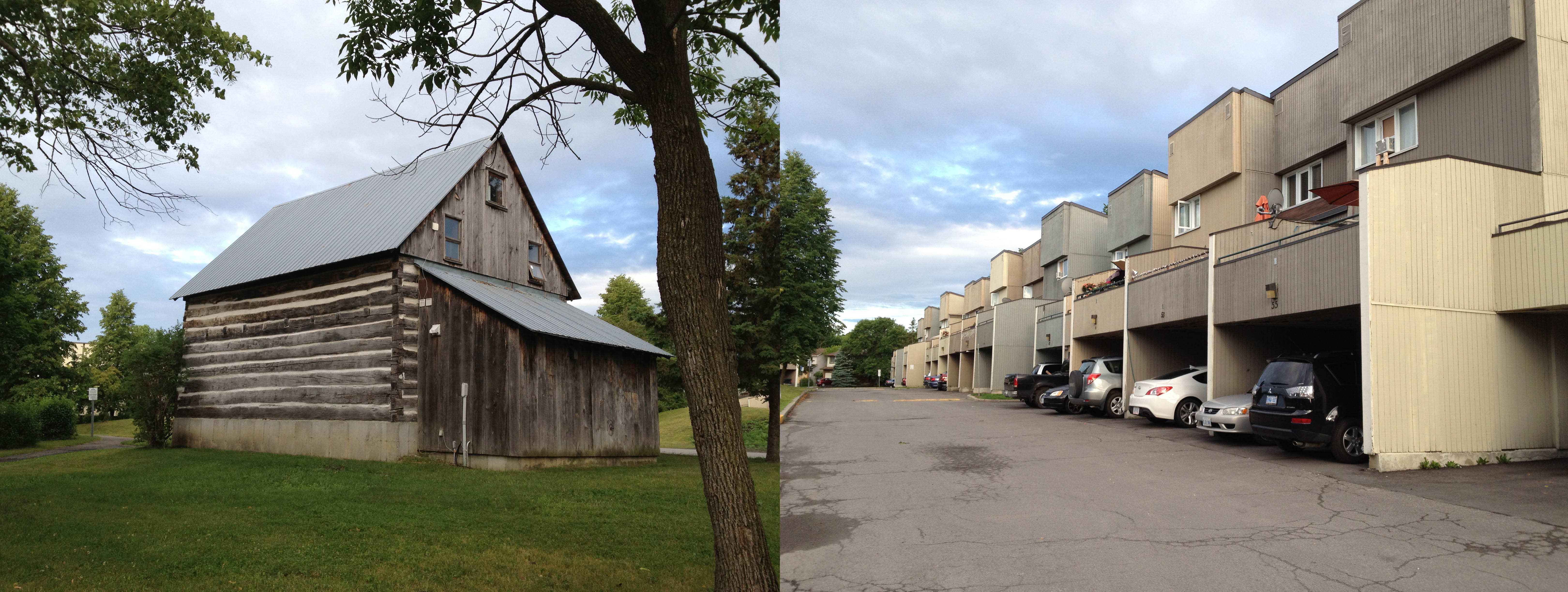
turning down Finch street I came upon this old log building, surrounded by these row houses.
Old & New
Here is it’s story.
In other news, a blue heron scared the bejeezles out of me when it took off as I passed right beside him along the bike path in the arboretum on my way to Hunt Club Woods, Estate & Chase. Glorious elegant birds they are.
There are a few streets in the Alta Vista neighbourhood I still haven’t travelled down, so this morning I set off in that direction, destination Tweed Avenue.
.
This is Tweed Avenue……………………………………………………… and this is tweed.
Tweed
Tweed is a rough unfinished woven wool – solid, hardy, not too risky. As a result of it’s rough weave, small variances occur, contributing in part to it’s endearing character. Same thing with Tweed Avenue, or rather this part of Alta Vista in general. Take, for example, the front yard on Colson Avenue shown below, completely covered in potted plants.
Colson Ave
Or this skate/bike sculpture on the roof of a mini mall.
Bike Sculpture
All of the streets I biked along in this area are shaded by hearty trees, which stand proudly in front of detached single family homes.
Tree canopy
Pleasant Park Road is different. For whatever reasons, perhaps because it is more of an arterial road, or maybe because the yards extend further back, it appears to be a more coveted street adress, as indicated by newer monster homes like this.
I first biked along the NCC Experimental Farm Pathway when I arrived in Ottawa a few decades ago, as my older sister lived on Fisher Avenue across the farm from the Carleton University residence where I was staying. I’ve since travelled its entire length, which terminates much further west, beyond Woodroffe Avenue.
The fact there is a huge farm plopped in the middle of a city is wonderful, but the portion of the path that passes through the centre of the farm that gives it it’s name is just one hi-lite to this route, as it travels through at least three distinct natural environments over it’s entire length. Here it is:
First the farm.
Near Fisher Avenue looking east.
Now why, you might ask, does the path jog to one side at this location? Well in that spot there used to be a concrete pad filled with a huge pile of dung. This, after all, is a farm. It made for some interesting olfactory experiences as you biked by. The pile is gone, but the route the path took around it still remains.
After crossing Merivale Road the path then climbs up and down through a wooded section, until it reaches Maitland Avenue.
Woods
If farmland and woods aren’t enough for ya, the final stretch to Woodroffe winds through fields of tall grass and wild flowers. What I find most amazing is not just the rich diversity of environments experienced along the route, but also how the path snakes it’s way towards the outskirts of the city without ever feeling encumbered by development. Quite the accomplishment.
Decided to check out Cleopatra Drive within the Merivale Industrial Area. Unfortunately it did not live up to it’s glorious namesake in any way, so I chose to leave the adjoining Caesar Avenue for another day. There wasn’t a way into the network of trails within Pinhey Forest from Cleopatra Drive so I took West Hunt Club Road to where it crosses a bike path that leads to the entrance to Piney Forest. West Hunt Club has wonderful large shoulders for bicyclists to ride on, as does Prince of Wales Drive. Too many drivers speed recklessly along both streets.
Pinhey forest: What a wonderful discovery! The lacework of trails are easily navigable due to this system of way finding with signs at each intersection.
Pinhey Forest
The MET. No it’s not a new Cineplex or library. It’s a honking big church! Corner Prince of Wales and West Hunt Club.
Church!
This has nothing to do with today’s ride. It’s the final race of the day heading down Rochester Street near Dow’s Lake as part of this year’s Italian Week celebrations. Those guys were zippin’!
Headed south-east to cover a few yet-to-be-traveled streets within the triangular area bordered by Bank, Heron and Walkley. Getting there by bike, especially from downtown, can be pretty tricky. This is my preferred circuit. Apart from the narrow section of road between Hogs Back and Riverside Drive,the route is mostly bike path or quiet road.
The Arboretum
If you are early enough you can catch soldiers from HMCS Carleton, a unit of the Canadian Forces Naval Reserve on a morning run in full fatigues. That’s them barely visible between the trees. Soldiers trainingCrossing the canal at the locks at Carleton University, and following the bike path on the opposite side up to Hogs Back, you might happen upon a duck family like this one. Ducks!
There are many wonderful views of Hogs Back Falls to be had from pathways on either side and above.Hogs Back Falls
Along Brookfield Road, just before reaching the Airport Parkway there is a fun section of bike path that dipsy-do’s under the parkway, over a stream and across two train tracks before continuing on as Brookfield Road on the other side. Dipsy-do path
There is then another short path at the end of this section of Brookfield that cuts through to Bank Street.
From there you’re on your own.
A section of today’s ride took me down a path that runs alongside Nepean Creek between Merivale Road and Prince of Wales Drive. It’s a little nature sanctuary, with vigorous building construction and development on the south side.
Along the path I came upon two poems cast into bronze plaques. Down the Merivale Road by William Wilfred Campbell and Le cronyism by Alfred Garneau. Turns out this trail is part of the Poets’ Pathway which, until today, I knew nothing about. I look forward to exploring more of it on my biking adventures.
Neat name for a street so I checked it out – quiet, no sidewalks, big coniferous trees on the west side, and this fabulous garden on the east. Zephyr Avenue
Then I ventured across Howe Street into the Village of Britannia. Now part of Ottawa, it still retains it’s own quaint and quirky personality. This wiki link tells you more about its history. These images show some of it’s quirky mix.
Britannia Village
A bit further on is the Britannia yacht club.
This very cool tall ship called the Black Jack was docked there. Black JackIf you aren’t intimidated by the MEMBERS ONLY – ALL OTHER TRESPASSERS WILL BE PROSECUTED sign, you can venture a bit further around the inlet where the boats are docked to get a glimpse of the Des Chênes rapids, however a more impressive view can be had from the other side of the Ottawa river. A bike route to get there is nicely described here.
Venturing further downstream along Cassels Street one passes a little birders paradise. Lot’s of feeders and places to sit and bird watch on the edge of Mud Lake. The road ends at the Britannia water filtration plant. This location affords lovely views of the Ottawa river without the threat of being arrested.
Biked to and along Thurston Drive, because I never have before.
From Pleasant Park I joined a bike path which takes you through the Kilborn Allotment Gardens – an amazing HUGE community garden. This photo doesn’t do it justice – you have to see it for yourself.
Mika and I tend a little vegetable plot in the much smaller community garden at Lisgar and Lyon. I highly recommend it, even if you don’t know how to garden. I never even grew my own dandelion before we started ours last year, and we managed to cultivate some wonderful veggies, especially tomatoes. Community gardens are a fabulous way to meet people of all walks of life and share their gardening customs and preferences.
So, turns out Thurston Drive is a business park, as this wonderful period sign announces when entering off Conroy Road. I’m thinking 1970’s, back when the city crest was it’s logo, and poured concrete was very stylin’.
It’s a nice little business park – lot’s of greenery.
Here’s what can be seen at the other end of Thurston Drive.
Here is a fabulous ride to Petrie Islands Park along the Ottawa River Pathway. Starting from Centretown it’s a 27 km ride one way, or 54 km return.
It’s always a good sign when long sections of the chosen bike route are designated as dark green in Google Maps. That means bike paths.
The Ottawa River Pathway is the most serene ride in the region. Long stretches hugging the shoreline without interruption and the sound of the tight packed stone dust crunching beneath one’s tires is mesmerising, particularly in the early morning as the mist rises up off the river and teams of rowers can be seen gliding across the water’s surface.
Once arrived at Petrie Islands Park you can go for a hike along the Turtle Trail and River Loop Trail. The info centre is very precious, run by volunteers who are passionate about conserving this natural habitat. There’s also a very nice beach on Petrie Island.
On the way back I took advantage of the NCC Sunday Bikedays whereby on Sundays throughout the summer they close off major parkways under their jurisdiction to motorised vehicules. The level of participation I witnessed along the Rockcliffe Parkway was incredible – all ages, on all sorts of bikes and rollerblades. Very inspiring.