Strathcona Park is a picturesque tract of greenery that runs along the west bank of the Rideau River at the eastern edge of the Sandy Hill neighbourhood. One can meander along a network of paths, past big old trees and features like the Strathcona Fountain sculpted by Mathurin Moreau , donated by Lord Strathcona in 1909, or the unique play ground structure designed by artist Stephen Brathwaite that incorporates carved blocks of stone recovered from prominent Ottawa heritage buildings.
Strathcona Park is also the staging ground for professional theatre throughout the summer! Odyssey Theatre has been performing Italian commedia inspired productions there since 1985. This is the opening weekend of their production Lysistrata and the Temple of Gaia.
Odyssey Theatre – Lysistrata and the Temple of Gaia Clockwise from top left – Catriona Leger, David Warburton, Natalia Gracious & David DaCosta
A Company of Fools – Twelfth Night Left to right – Garrett Quirk, Kate Smith, Kate McArthur
UPDATE- September 2018: Another fine season of theatre has come and gone, but fear not! Next summer promises to once again be the staging grounds of more wonderful productions by Odyssey Theatre and A Company of Fools!
With the 2015 opening of the Adawe Bridge over the Rideau River, Strathcona Park became much more accessible to cyclists from points east. This route explores how to get there from the west, starting in Centretown. The purple line is an alternative deviation on the return trip to avoid having to ride amongst traffic on Laurier, as the west bound segregated bike lane only starts at Elgin. If anyone needs a different bike route to get to Strathcona Park let me know & I’ll figure it out.
We begin our journey at the western end of the Laurier bike lane at the intersection of Laurier & Bronson.
Start of Laurier Bike Lane heading east from Bronson
Head all the way east along the Laurier Bike Lane to where the path passes infront of City Hall after crossing Elgin Street. Just before Laurier heads over the canal, turn onto the sidewalk along the exit to Queen Elizabeth Driveway. Just a few feet along the sidewalk it becomes bi-directional shared pathway.
Exit off Laurier Bike Lane before going over the bridge.Sidewalk along exit lane becomes multi-use path
Cross Queen Elizabeth Driveway at the 4 way stop and head south along the Rideau Canal Western Pathway.
Crossing the Queen Elizabeth Driveway to the Rideau Canal Western PathwayRiding along the Rideau Canal Western Pathway
Not too far along you will see the Corktown pedestrian/bike bridge to your left heading over the canal. Cross it.
Exit off the Rideau Canal Pathway onto the Corktown Bridge – follow that guy.View up the canal for Corktown Bridge
Continue down to the signalised crossing at Colonel By Drive and ride under the transitway and up along the winding path to the Ottawa U campus.
Crossing Colonel By Drive heading under the transitway (they were putting down nice new pavers)
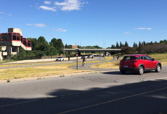
Ride straight ahead along Marie Curie Private and across King Edward Avenue at the lights. Head straight on down the hill along Somerset St East. Bike lanes appear a couple of blocks past King Edward that lead all the way to Strathcona Park.
Bike lanes along Somerset St EastEntrance to Strathcona Park at Somerset St East.Path through Strathcona Park
Odyssey Theatre’s performances are at the northern end of the park, while The Fools set up a little closer to Somerset, as indicated on the above map. I’ve also spotted the location of the Strathcona fountain and the Brathwaite play structure on the map.
Play structureStrathcona FountainView down the Rideau River from the path along the river’s edge
Updated – July 23rd, 2018: On Sunday, July 22nd there was a pop-up bike lane installed along Moodie Drive in Bells Corners for cyclists to try out. The Healthy Transportation Coalition was behind this great initiative which you can read more about by clicking here. An important part of their goal is to demonstrate the need for safe cycling infrastructure on Moodie Drive in Bells Corners West.
Here’s a bike route for those located closer to downtown who are interested in riding out to Bells Corners! The purple line indicates the location where the pop-up bike lane was installed.
As the event landed on a Sunday, the first section of this route capitalised on the weekly Sunday Bikedays event when the Sir John A Macdonald (SJAM) Parkway westbound lane along the Ottawa River is closed to traffic, starting from the War Museum and continuing all the way west to Carling Avenue.
SJAM Parkway is re-opened to cars at 1pm on Sunday Bikedays, so the orange line on the map proposes an alternative return route from the Pinecrest Creek Pathway that is primarily along the Experimental Farm Pathway. Or one could ride along the Ottawa River Pathway that runs parallel to the SJAM Parkway.
Riding along the Sir John A Macdonald Parkway during Sunday Bike Days
Just before Carling there is an oppportunity to get onto the Pinecrest Creek Pathway just off the SJAM Parkway exit.
Getting onto the Pinecrest Creek Pathway (there won’t be any cars on Sunday morning like that red one)
The path goes under the Queensway and up to Iris St, then continues on the opposite corner of Iris, like so.
Corner of Iris & Transitway
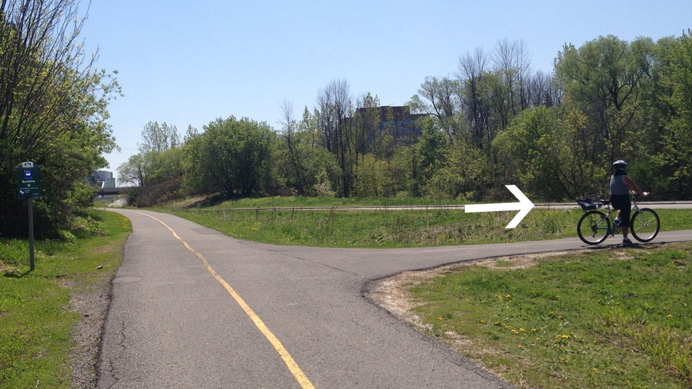
Further along there is a path off to the right. There is a sign (barely visible on this photo) pointing to it that reads ‘Baseline’. If you miss the turn off and wind up by the fire station on Woodroffe you’ve gone too far.
‘Is that arrow still following me?’, thought Carla as she paused to wait for her partner to take another picture.
After curling up and under Baseline Road the official path circles around a bus parking lot, however most continue straight to avoid this detour.
Detour around bus parking at Baseline
The path continues parallel to Woodroffe, then veers west just before reaching the Legacy Skatepark. It then continues westwardly, twice crossing Centrepoint Drive.
Bike path west, away from Algonquin College
The path dips under the train tracks and ends a bit further at Craig Henry Drive.
Heading under the train tracksPath just before Craig Henry Drive. Follow the light posts to avoid taking a wrong exit.
Craig Henry Drive has a painted shoulder but it is not signed as a bike lane so there is a chance you may have to bike around the odd parked car. Follow Craig Henry Drive all the way to Greenbank Road.
painted lane along Craig Henry Drive
On the opposite side of Greenbank continue along Canfield Road for a short distance before hopping onto another path. To access this path take the closest cut in the curb which is a few yards away from the start of the path, infront of some communal mailboxes.
Accessing the path heading west off Canfield Road
This section of path weaves it’s way through a wooded area before crossing McClellan Road, and then follows power lines all the way to Bruce Pit.
Woodsy section of path before crossing McClellan……and along power lines after crossing McClellan
Once arrived at Bruce Pit turn right and follow the packed stone dust path that circles the Pit.
Entering Bruce Pit onto the stone dust pathGravel path around Bruce Pit
Cross Cedarview Road on the west side of Bruce Pit and then ride along the bridge, that has bike lanes, over the 416 highway.
Bridge over the 416
Once on the other side of the 416 cut through to the northwest corner of Bell High School campus. Just beyond the black chain link fence there is a short path off to the right that leads down to Stinson Avenue.
Path beyond the chain link fence leading down to Stinson Ave
Stinson Ave is a quiet residential street, as are Delta St, Evergreen Dr, Ridgefield Crescent, Longwood Ave, Tanglewood Dr and Hadley Circle which I followed as per the above map all the way to our final destination on Moodie Drive.
The Merry Dairy is a wonderful ice cream parlour at the corner of Gladstone and Fairmont Avenue, a perfect destination on a warm Summer’s day! Here’s a bike loop from the Trillium Pathway and back. (The Trillium Pathway is also popularly known as the O-Train Pathway. Some wayfinding signage uses this name as well).
We begin at the bottom of the path that comes down from Somerset Street and joins the Trillium Pathway. Head south along the pathway.
Starting off for ice cream! Mmmm….
After crossing Gladstone, the path continues under the Queensway.
Crossing Gladstone…. and heading under the Queensway
Just beyond the Queensway there is an exit to the right that crosses over the O-Train tracks along a pedestrian bridge to Young Street.
Exit off Trillium Path…across the bridge to Young St
Continue up Young Street all the way to Fairmont Avenue. Turn right on Fairmont Avenue and ride back under the Queensway.
Straight on Young St….. & right on Fairmount
Nota bene: The Merry Dairy also has an ice cream truck that attends various events around town. On the evening of July 21st it will be in Fairmont Park where A Company of Fools will be presenting Twelfth Night! To get there, turn left once you reach Fairmont Avenue and ride south for a couple of blocks. I’ve indicated this option in purple on the above map. (UPDATE Spring 2021 – Performances by A Company of Fools are on pause until we get through this Covidian mess).
Twelfth Night in Fairmount Park on July 21st!
A block north of the Queensway you’ll find the ice cream parlour on the south west corner of Fairmont and Gladstone.
The Merry Dairy!
AND they love cyclists! For example, when it came time to purchase a bike rack they surveyed the Ottawa biking community via Twitter who overwhelmingly preferred this model.
Merry Dairy bike rack
The service is great and the ice cream is delicious!
Time for ice cream!
To get back to the Trillium Path, continue north along Fairmont across Gladstone to the lane opposite Duhamel Street. Turn right onto this lane which takes you to quiet Irving Avenue.
Laneway between Fairmount and Irving Ave
Turn left on Irving, them right on Laurel, and follow Laurel all the way to Breezehill Ave N. Turn left onto Breezehill. These are all pretty quiet residential streets. You’ll pass Devonshire Elementary School at the corner of Laurel and Breezehill.
Turning onto Laurel from IrvingPassingby Devonshire School on Breezehill Ave
Heading north along Breezehill takes you to Somerset. Turn right onto the bike lane over the Somerset bridge.
Breezehill and Somerset
On the opposite side of the bridge there is a right hand exit onto the path that leads dowm to the Trillium Path to where our adventure began.
Somerset Bridge bike lane to exit…..leading down the hill to the Trillium/O-Train Pathway
Et voila!
If anyone needs directions to the Trillium Path please let me know and I will post a route.
This Saturday A Company of Fools will be performing Shakespeare’s comedy Twelfth Night in Flannery Green, a park located just east of Mooney’s Bay. Here’s a bike route Carleton summer students can follow along the canal to catch either the 2pm matinee or the 7pm show!
UPDATE: July 16, 2018 – The performances were a big success, so there is a strong possiblity the Fools will be back to perform in Flannery Green next summer! In the meantime, dear alma mater, this is a great route to Mooney’s Bay Park if ever you need a break from studies. Hog’s Back Falls are also a pretty spectacular site to behold, especially in the Spring.
Starting from the hub of resident buildings on campus, head up to where there is a link to get across Colonel By Drive to the Rideau Canal Eastern Pathway, right beside the Hartwell Locks.
Start! from Carleton student residency’s.Path link off Library Road towards the Colonel By crossing.
There aren’t traffic lights at this crossing, which has been a contentious issue as it is a popular pedestrian and bike access to campus. A compromise solution was to create a mini lay-away island between the two speedy lanes of traffic.
Crossing Colonel By Drive to the Rideau Canal Eastern Pathway.
Once across Colonel By Drive turn left and head upstream along the Rideau Canal Eastern Pathway.
Biking up the Rideau Canal Eastern PathwayHeading up past the locks, under Hog’s Back Road
The path goes under Hogs Back Road, then curls up to Mooney’s Bay. Follow the path along Hog’s Back Road that goes over the Rideau River.
First sight of Mooney’s BayHeading over the Rideau River along Hog’s Back Road
Once over the bridge veer right and head through Mooney’s Bay Park.
Veering right towards Mooney’s Bay ParkNorthern entrance to Mooney’s Bay Park
Mooney’s Bay has a great big beach for those in need of a cool dip. It’s also a very popular weekend destination for huge events such as the Dragonboat Festival and various other rowing regatta’s. This weekend it will be the Hope Volleyball Tournament.
Beach at Mooney’s Bay
Continue through the park along the path towards the southern end where there is a short link to the traffic lights that take you across Riverside Drive.
Exit off path towards lights across Riverside Drive
Once across Riverside Drive, head straight along Mooney’s Bay Place, a residential street that brings you right to Flannery Green.
Bruce has been a long time resident of Orleans. When asked for his opinion on places he thought a visitor might find interesting in his neck of the woods, he generously offered a few suggestions which I have linked together into the following bike route!
We begin at the western end of Hiawatha Park and follow a path that weaves it’s way though the residential neighbourhood. This is also the park where A Company of Fools will be performing Twelfth Night this Thursday night! UPDATE, Fall 2018: The show was a great hit! You can follow this link to see what the Company of Fools are up to next!
Hiawatha Park with Twelfth Night model
Halfway along the path through Hiawatha Park I turned north towards the Ottawa River via Hiawatha Park Road. Near the northern end of the road there are two interpretive panels that describes the history of Orleans. One panel details the origins of Bruyere Village which the panels are facing, and the Grey Nuns who were it’s initial residents. The second panel details the history of Louis-Théodore Besserer and the influence he had on the formation of Orleans, including the origin of it’s name.
There is a pleasant little park at the end of the street with a fine view across the river.
View across the river at the end of Hiawatha Park Road
Next I retraced my treads a short distance up Hiawatha Park Road to where there is access to a bike path that heads east. Bruce mentioned the numerous branches off of this path that lead through the woods down to the rivers edge, in particular the one across from Bilberry Drive.
Path opposite exit to Bilberry Drive
As one approaches the river along this trail the ground surface transitions from stone dust to packed dirt.
Transition in Bilberry path surfacing
The path follows along the river a short distance, affording some pretty great views across the water and into the woods. Bring bug spray.
Views along Bilberry path
Now back on the main path, the next area Bruce mentioned was the stretch between Champlain St and 10th Line Road. The beauty of this section of path is hard to capture in a photo. There is a wonderful cacophony of wildlife in the surrounding canopy of trees and sloped forest floor rising up on the right.
Path between Champlain & 10th Line
To get to our final destination requires heading inland across a few major traffic arteries. Fortunately there are multi-use paths and bike lanes along Trim Road with a couple of round-abouts to keep things calm.
Trim Road bike infrastructure
I then turned right onto St Joseph Boulevard which has bike lanes as far as our final destination, the Princess Louise Falls. The falls are on the south side of the road which requires waiting until there is a long break in traffic to cross, or riding up to the lights at the 174 on ramp, then coming back on the south side. I don’t reccomend trying to get to the falls via 10th Line Road unless you are comfortable riding with lots of speeding heavy traffic. I tried. It sucked. The vantage point of the falls is pretty far from the road, although after a heavy rain fall or in the Spring they would appear quite dramatic even from this vantage point. There is a hiking trail that brings you closer however this would require a mountain bike to negotiate, if they are permitted.
Princess Louise Falls
Et voila! Thanks Bruce for all the great suggestions.
A Company of Fools is Ottawa’s longest running professional Shakespeare Company. This summer they will be performing Twelfth Night in parks Throughout the region. On June 30th the show previews in Lynwood Park located in Bells Corners. Hannah is considering biking there from her neighbourhood in Bel-Air Heights so here’s a bike route that is almost entirely along multi-use paths! (UPDATE – Fall 2018 : The Twelfth Night tour is over, however this route continues to serve as a convenient connection from Bells Corners to areas further east!)
Our journey begins at the intersection of Iris & Navaho. I headed a short distance along Iris Street to where it crosses the Experimental Farm Pathway. That’s where I got onto the path and headed west.
Joining the Experimental Farm Pathway heading West at Iris Street
The Experimental Farm Pathway ends at Woodroffe however there are traffic lights to get across the street to where the Pinecrest Creek Pathway begins on the other side, just beside the fire station.
Crossing at Woodroffe and turning infront of the fire station to where the Pinecrest Pathway continues on the other side.
The path curves down hill, at the bottom of which I took the exit that heads across the Transitway.
Exit off the Pincrest Creak Pathway that crosses the Transitway
After curling up and under Baseline Road the official path circles around a bus parking lot, however most continue straight to avoid this detour.
Detour around bus parking at Baseline
The path continues parallel to Woodroffe, then veers west just before reaching the Legacy Skatepark. It then continues westwardly, twice crossing Centrepoint Drive.
Bike path west, away from Algonquin College
The path dips under the train tracks and ends a bit further at Craig Henry Drive.
Heading under the train tracksPath just before Craig Henry Drive. Follow the light posts to avoid taking a wrong exit.
Craig Henry Drive has a painted shoulder but it is not signed as a bike lane so there is a chance you may have to bike around the odd parked car. I followed Craig Henry Drive all the way to Greenbank Road.
painted lane along Craig Henry Drive
On the opposite side of Greenbank I continued along Canfield Road for a short distance before hopping onto another path. Canfield Road is a residential street however some drivers do speed along this stretch of road. For those wishing to avoid riding along Craig Henry Drive and Canfield Road I have indicated an alternative route on the map in orange.
Canfield Road.
To access the path off Canfield I took the closest cut in the curb which is a few yards away from the path, infront of some communal mailboxes.
Accessing the path heading west off Canfield Road
This section of path weaves it’s way through a wooded area before crossing McClellan Road, and then follows power lines all the way to Bruce Pit.
Woodsy section of path before crossing McClellan……and along power lines after crossing McClellan
Once arrived at Bruce Pit I turned right and followed the packed stone dust path that circles the Pit.
Entering Bruce Pit onto the stone dust path
The path around Bruce Pit is quite lovely. There’s a fence along one side as the centre of Bruce Pit is a huge dog park.
Gravel path around Bruce Pit
I crossed Cedarview Road on the west side of Bruce Pit and then rode along the bridge, that has bike lanes, over the 416 highway.
Bridge over the 416
Once on the other side of the 416 I cut through to the northwest corner of Bell High School campus. Just beyond the black chain link fence there is a short path off to the right that I followed down to Stinson Avenue.
Path beyond the chain link fence leading down to Stinson Ave
Stinson Ave is a quiet residential street, as are Delta St, Evergreen Dr and Ridgefield Crescent which I followed all the way to our final destination, Lynwood Park. If you are a fan of mid-century modern houses there are lots of well preserved examples in this part of Bells Corners.
Mid-Century Modern home in Bells Corners
Here’s a bit of Lynwood Park.
Lynwood Park
And finally, a taste of what the set will look like in the park.
Twelfth Night final model in Lynwood Park. Designer – Me!
If anyone is looking for a bike route to any of the parks where Twelfth Night will be staged, feel free to send me a starting point and I will try to post a route. Here is a link to the schedule of parks and performances throughout the summer.
The annual Summer Solstice Indigenous Festival Pow Wow will be held this coming weekend in Vincent Massey Park. I went last year and it was fantastic! For those thinking of biking to the Pow Wow, here is a route that starts at the Gathering-Ring, an art installation on the Ottawa side of the Portage Bridge, just off the bike path. This route is almost entirely along multi-use pathways.
The Gathering-Ring
From the Gathering-Ring we headed north a short distance before turning off to the right down onto the Ottawa River Pathway that circles under the Portage Bridge. On either side of the wide underpass a group of artists have just completed a series of large paintings in honour of National Indigenous Peoples Day that takes place annually on June 21st.
Two of the paintings installed on the walls of the Portage Bridge underpass
A short distance further along the pathway there is another wide underpass. An exhibit of large photographic reproductions of works by indigenous artists from across the country are on display along the walls of the underpass.
Exhibit: From here to there (then and now)
The path continues past the Mill restaurant, then crosses Booth Street and follows the edge of the Ottawa River.
Ottawa River Pathway
Just beyond the War Museum there is an interpretive display describing the river as a vital travel route for Indigenous peoples and others that followed.
Interpretive display on the Ottawa River
We then turned off the Ottawa River Pathway onto the Trillium Pathway and headed south, all the way to Prince of Wales Drive.
Exit to the left from the Ottawa River Pathway onto the Trillium PathwayTrillium Pathway heading under SJAM Parkway
The section of the Trillium Pathway between Carling and Prince of Wales Drive is gravel or dirt, however there are plans to have it paved.
UPDATE – Fall 2018 – This section has been paved – YAH!
Trillium Path between Carling & Prince of Wales Drive – before and after being paved
We turned right along Prince Of Wales to get to the lights that cross over into the Arboretum. There is a bike lane along Prince of Wales, but the painted lines along this section are so worn out as to be indiscernible. We hugged the old exit lane to the no longer existing Sir John Carling Building.
Section of poorly maintained bike lane along Prince of Wales Drive
Once safely across Prince of Wales Drive we followed the stone dust path through the Arboretum, then up along the paved pathway to the Hartwell Locks.
Path through the Arboretum
We pushed out bikes across the top set of locks, carrying our bikes up and down the three steps on either side.
Crossing the Hartwell Locks
We then followed the Rideau Canal Pathway all the way to Mooney’s Bay.
Rideau Canal Eastern Pathway
The path circles up along Hog’s Back Road and heads across the bridge over the Hogs Back Falls. Once on the other side we turned right onto the Rideau River Eastern Pathway that circles back under Hog’s Back Road.
The Rideau River Pathway meanders a bit before heading down a long hill, flattening out just as it passes under Heron Road, and winding up in Vincent Massey Park on the other side.
Entering Vincent Massey Park along the Rideau River Pathway
For this year’s Ottawa Children’s Festival, one of the plays, The Legend of Swan River, will be performed at Remic Rapids Park, located 3 km’s upstream from the main site on Lebreton Flats. There will be a shuttle bus to transport audience members from Lebreton Flats to Remic Rapids Park, however one can also bike to the site along the very pleasant Ottawa River Pathway. Here’s how. UPDATE: May 18 – This year’s Children’s Festival has come and gone, but this route remains a great ride from Lebretton Flats to Remic Rapids Park.
Starting from the entrance arch to the Children’s Festival along Sir John A MacDonald Parkway, follow the path to the western end of Lebreton Flats where it joins the Ottawa River Pathway.
Entrance to Childrens Festival at Lebreton FlatsWhere the path through Lebreton Flats connects to the Ottawa River Pathway
Continue heading west and upstream. You’ll soon go over a little bridge before continuing along the edge of the Ottawa River.
Little bridge along the Ottawa River Pathway, just west of Lebreton Flats
The path also passes under the Prince of Wales train bridge, then meanders pleasantly all the way to Remic Rapids Park.
Path heading under the Prince of Wales train bridgeAnother view to be had along the Ottawa River Pathway on the way to Remic Rapids Park
There is a fork in the path just before arriving at the park. Stay to the right along the water’s edge.
Fork in the path
A short distance from the fork you’ll notice a concrete lookout. Take the gravel exit opposite the lookout. This is where the play commences.
Arrivée!
I didn’t notice any bike racks at the Remic Rapids site, however there are many sign posts around the edge of the parking to which one can lock your bike.
Back at the turn of the 20th century Ottawa had an incredibly creative and forward thinking character by the name of Thomas Ahearn. He achieved a myriad of ground breaking technological achievements in his time. For example he brought electric lighting to all our city streets way before the rest of the country caught on. With his business partner Warren Soper he created the Ottawa Electric Railway Company, building a network of streetcars and tracks whose routes opened up the city. He also designed and patented a number of electronic products, like the first electronic oven. He also drove an electric car. This bike tour visits a few sites in memory of Ahearn’s contributions to the development of Ottawa.
For a more detailed description of Thomas Ahearn I recommend checking out this Ottawa Citizen link . I have also included a number of other links at the bottom of this post.
Our tour begins in Lebreton Flats where in 1855 Thomas Ahearn first arrived on the scene. His parents were Irish immigrants who lived on the Flats where his father worked as a blacksmith. At the age 15 or 16 Thomas went from his home on the Flats to the J.R. Booth Company to offer his services in exchange for learning the exciting new technology of telegraphy.
On the Southwest corner of Booth and Sir John A MacDonald (SJAM) Parkway, across the street from the War Museum, sits an interpretive display on the history of Lebreton Flats. A heritage, non-functioning, public fountain acts as it’s introductory focal point. The original working fountain was commissioned in part by Ahearn himself in tribute to his mother-in-law Lilias Fleck, and was re-discovered when the soil in Lebreton Flats was being de-contaminated in the 2010’s. Further within this interpretive exhibit are two panels that touch on Ahearn and his many exploits. Lebreton Flats is where Thomas’ adventures began!
Entrance to Lebreton Flats interpretive display with the Fleck Fountain at the front1 of 2 interpretive panels further within the display that talks about Ahearn. That’s him in the middle.
After working for a few years in New York City, the hi-tech hub of the era, Ahearn re-settled in Ottawa and in partnership with his old friend from the Flats, Warren Soper, he built up a number of successful companies which they managed from their headquarters on Sparks Street, which is our first stop. To get there our route passes through the Garden of the Provinces and Territories park. At the south/east end of the park there is a ramp to get up to Sparks Street but it is quite narrow so we carried our bikes up the short flight of stairs.
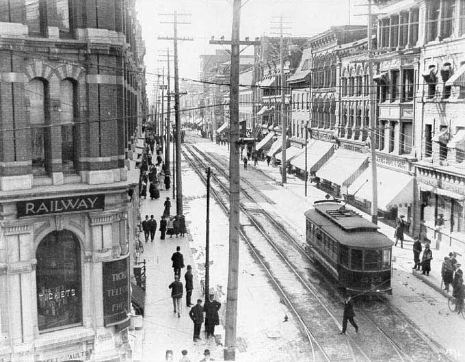
Ottawa Electric Railway Company streetcars used to travel along Sparks Street.
Sparks St back in 1909. Ottawa Electric Company building would be facing the third telephone pole on the left.
In 1927, Thomas Ahearn was chosen by Prime Minister MacKenzie King as the first chairman of the Federal District Commission, the predecessor to the National Capital Commission (NCC). In this role he greatly influenced the development of Ottawa’s parkway network, including the Queen Elizabeth Driveway. The Rideau Canal Western Pathway runs along the Driveway which we followed to our next destination – Lansdowne Park. That’s because the inaugural run of the Ottawa Electric Railway Company travelled down Bank Street to Lansdowne with Ahearn piloting one trolley and Sopper at the helm of another, with an impressive list of dignitaries along for the ride. It was also at Lansdowne where in 1892 Ahearn exhibited a number of his patents and won the first gold medal ever awarded by the Central Canadian Exhibitions Association.
At the extreme north-west corner of Lansdowne, where Holmwood and Bank Street meet, sits the second non-functioning water fountain on our tour. This one is dedicated to Ahearn himself. A history of the fountain pre-re-installation can be found at this link.
After visiting the Ahearn Fountain we cut through the Glebe to the path that runs along the O-Train and followed it all the way to the Ottawa River. We then rode west along the Ottawa River Pathway to Britannia Bay. Ahearn’s streetcar tracks were extended to Britannia Beach where he built an amusement park to encourage users of the streetcar to travel on weekends. The Ottawa River Pathway now follows the old streetcar line from where the path leaves the edge of the SJAM Parkway. The streetcar terminal structure at Britannia Bay is a reminder of this popular service.
Britannia Trolley Station
There is a short quiet residential street just a few blocks west of the old terminal station named in hounour of Ahearn. Our bike route includes the length of it.
Ahearn Ave
In 1899 Ahearn formed the Metropolitan Power Company to build a hydro electric power house where the Ottawa River narrows, just east of Britannia Bay. This included a 2000-foot canal extending to the lower end of the Lac Deschênes Rapids. This endeavor did not prove to be financially viable, so the top of the canal was converted into moorings for the Britannia Boat Club.
Top of Britannia Canal
Vestiges of the old canal can also be viewed by following Cassels Street and cutting across the grass to the waters edge at the spot indicated on the above map.
Other side of the black line in the middle is the ottawa River
Heading back along the Ottawa River Pathway, our tour crosses one of the few local bridges across the mighty Ottawa River, the Champlain Bridge. In his role as chairman of the Federal District Commission Ahearn played an instrumental role in promoting and financing the construction of the original Champlain Bridge. In 2002 it was rebuilt and this section of the original bridge was put on display on Bate Island, midway across the bridge with interpretive panels on the history of the bridge.
Hunk of original Champlain Bridge on Bate Island
The tour continues across the bridge along the bike lane to the Quebec side of the river, then east along the Voyageurs Pathway as far as the the Macdonald-Cartier bridge. There are bi-directional bike lanes along the eastern side of the Macdonald-Cartier bridge which we followed back over to the Ontario side of the river.
Our route continues along the Sussex Drive bike lane to the round-a-bout to the north of Rideau Hall. In the centre of the round-a-bout the NCC has installed a short section of streetcar tracks reminiscent of the original ones that brought passengers to and from Rockcliffe Park.
Streetcar tracks that extend into the round-about
The little heritage canopies one can observe while travelling along the Rockcliffe Parkway were shelters for passengers waiting for the streetcar.
Streetcar stop
Rockcliffe park was a popular destination for weekend streetcar passengers including skiers.
Our final destination is the resting place of Thomas Ahearn in Beechwood Cemetery. To get there we cut through Rockcliffe and then rode a short distance along the Beechwood Avenue bike lane before turning up into the cemetery where one can find this headstone identifying his and his loved one’s resting place.
Et voila, thus concludes our bike tour commemorating the phenomenal achievements of Thomas Ahearn. The following links lead to more in depth stories on the man.
Deschênes is a small community on the Quebec side of the Ottawa River, right where the river narrows into the Deschênes rapids after it makes a big swing past Aylmer. The Ottawa River played an important role in the rich history of our community.
Whenever a big river narrows, it creates a powerful current, especially attractive to capitalist entrepreneurs in the late 1800’s, a procession of which built various mills at this location.
The most noticeable feature while riding along the Voyageurs Pathway through Deschênes are the ruins of some of those old mills still holding their own in the middle of the river. But there is even more to discover in the immediate environs, as I learnt on a Jane’s Walk tour of the communtiy earlier this year.
Here is a bike route from Ottawa to Deschênes and back, along with stops at some of the spots described on the Deschênes Residents Association map that are accessible via velo.
This ride begins in Ottawa where the bike lanes along Laurier and Bay meet. I made my way north along Bay to Wellington before crossing over to Quebec along the Portage Bridge bike lane. I then got on the Voyageurs Pathway and followed it all the way to Deschênes. First stop is at Simard Bay below the Deschênes rapids, with a fine view out over the river.
Simard Bay
A short distance up stream one arrives at the rapids with great views of the ruins.
Mill ruins
The area is also good for bird watching. There are interpretive panels with french descriptions of a few fine feathered friends one might spot while visiting as well as why this site is an important bird habitat.
Birds & Rapids
Next stop along the Voyageurs Pathway is the wooden bridge that crosses over the marsh just west of the rapids. It is magical riding through this short section. Definitely worth a pause to take it all in.
The Dupéré bridge and wood duck marsh
I continued along the Voyageurs Pathway and then turned east along the old track bed that runs parallel to Boulevard de Lucerne.
Variegated stone dust/dirt surface along old track bed
In the late 1800’s an electrical generating station was built at the rapids in part to run trams between Ottawa and Aylmer. One of the oldest remaining buildings in Deschênnes is associated with this endeavour. The long stone building at the corner of Lucerne and Vanier was the tram way car barn. I believe this is where they were stored. A fine historical reference photo can be found here.
This is what it looks like now.
Tramway barn as it appears today
After checking out the old tramway barn I rode back to the Voyageurs Pathway along the brand-spanking-new Chemin Vanier bike lane!
Bike lanes along Chemin Vanier
I then rode back to Ottawa via the Voyageurs Pathway, crossing the Ottawa River over the Island park Drive bridge. Once across I followed the Ottawa River Pathway towards downtown.
I’ve described just a thin slice of the many layers that make up the rich history of the Deschênes community. The Jane’s Walk tour of the area given by Howard Powles is definitely worth checking out if he decides to give it again next year.