
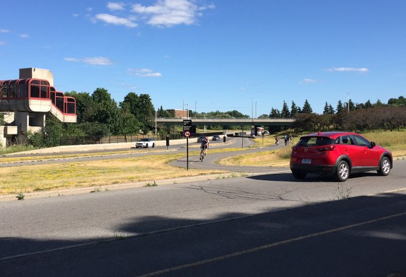
Updated – July 23rd, 2018: On Sunday, July 22nd there was a pop-up bike lane installed along Moodie Drive in Bells Corners for cyclists to try out. The Healthy Transportation Coalition was behind this great initiative which you can read more about by clicking here. An important part of their goal is to demonstrate the need for safe cycling infrastructure on Moodie Drive in Bells Corners West.
Here’s a bike route for those located closer to downtown who are interested in riding out to Bells Corners! The purple line indicates the location where the pop-up bike lane was installed.
As the event landed on a Sunday, the first section of this route capitalised on the weekly Sunday Bikedays event when the Sir John A Macdonald (SJAM) Parkway westbound lane along the Ottawa River is closed to traffic, starting from the War Museum and continuing all the way west to Carling Avenue.
SJAM Parkway is re-opened to cars at 1pm on Sunday Bikedays, so the orange line on the map proposes an alternative return route from the Pinecrest Creek Pathway that is primarily along the Experimental Farm Pathway. Or one could ride along the Ottawa River Pathway that runs parallel to the SJAM Parkway.

Just before Carling there is an oppportunity to get onto the Pinecrest Creek Pathway just off the SJAM Parkway exit.
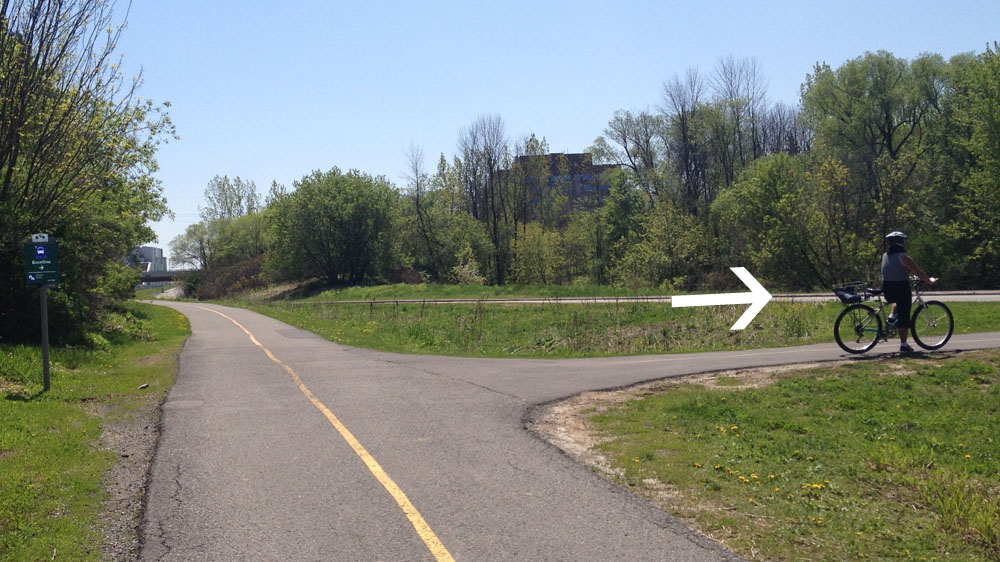
The path goes under the Queensway and up to Iris St, then continues on the opposite corner of Iris, like so.

Further along there is a path off to the right. There is a sign (barely visible on this photo) pointing to it that reads ‘Baseline’. If you miss the turn off and wind up by the fire station on Woodroffe you’ve gone too far.
After curling up and under Baseline Road the official path circles around a bus parking lot, however most continue straight to avoid this detour.

The path continues parallel to Woodroffe, then veers west just before reaching the Legacy Skatepark. It then continues westwardly, twice crossing Centrepoint Drive.

The path dips under the train tracks and ends a bit further at Craig Henry Drive.


Craig Henry Drive has a painted shoulder but it is not signed as a bike lane so there is a chance you may have to bike around the odd parked car. Follow Craig Henry Drive all the way to Greenbank Road.

On the opposite side of Greenbank continue along Canfield Road for a short distance before hopping onto another path. To access this path take the closest cut in the curb which is a few yards away from the start of the path, infront of some communal mailboxes.

This section of path weaves it’s way through a wooded area before crossing McClellan Road, and then follows power lines all the way to Bruce Pit.

Once arrived at Bruce Pit turn right and follow the packed stone dust path that circles the Pit.


Cross Cedarview Road on the west side of Bruce Pit and then ride along the bridge, that has bike lanes, over the 416 highway.

Once on the other side of the 416 cut through to the northwest corner of Bell High School campus. Just beyond the black chain link fence there is a short path off to the right that leads down to Stinson Avenue.

Stinson Ave is a quiet residential street, as are Delta St, Evergreen Dr, Ridgefield Crescent, Longwood Ave, Tanglewood Dr and Hadley Circle which I followed as per the above map all the way to our final destination on Moodie Drive.

Et voila!
