InsulBrick is a tar coated fibreboard siding introduced in the 1930’s that was super popular up to and throughout the 1960’s. It has a slightly embossed stone or brick pattern, enhanced with added granular material on the outer surface. It hasn’t been manufactured since the early 70’s, so what’s out there is the real McCoy. All surviving examples show signs of aging, some gracefully, others, not so much. Regardless, all suggest a rich history of protecting generations of occupants thoughout all the conditions imposed by our wildly diversified climate.
10 years ago I posted a first bike tour of local InsulBrick covered houses. The following route re-visits the surviving examples, along with others that I have since discovered around Ottawa/Gatineau. There seems to be no desire by local heritage groups to preserve examples of this vanishing form of mid-century faux-wunder-cladding, so I have included photos of the buildings that have since vanished, identified as white ghost markers on the map. You can see what they looked like by clicking on their respective markers.
InsulBrick has also become a popular generic term to describe the tar impregnated exterior covering first patented in 1932 as Inselbrick and includes Inselstone, Inselwood and a few other imitations.
First stop is this great example at the corner of Armstrong St and Hinchey Avenue in Hintonburg. Many other older houses along Armstrong have recently been torn down and replaced with boxy infills but this house survives! I spoke to the owner, a very friendly french woman, who said they have no plans to replace or cover the insulBrick surfaces. One senses a lot of tender loving care goes into maintaining this home.

Next stop is on Breezehill Ave S. which could very easily be mistaken for a brick house, but it’s InsulBrick! The clearest indication is how the pattern does not reproduce the 2 to 1 overlapping stacked brick pattern on the corner where the walls meet. The clever use of ivy helps too.

There are two more examples in this neighbourhood two blocks over on Champagne Ave S. This first one has a faux cut stone pattern.

A few doors down you will find this more eclectic example.

Our next destination is 642 MacLaren Street, and what a beauty it is! So well preserved, one has to take a really close look to see that it is in fact InsulBrick. As mentioned at the Breezehill stop, corners are where the truth is told. To hide how Insulbrick patterns don’t correspond to real brick at corner junctions, a corner strip is often applied, as was in this case.

A few blocks over on Florence St this house has been holding its own, with the preserved carved porch detailing on the porch set in contrast to the darker InsulBrick.

Over on 446 Lisgar St the InsulBrick was poorly added to the front portion of an already existing building. This example is really showing it’s age, especially in contrast to the original brick still visible on the back portion of the building. Most of the houses visited on this tour were originally clad in Insulbrick, but it wasn’t uncommon for additions to older homes, once additions were added, that Insulbrick be used. For example the 100+ year old house we live in in Centretown, not far from this house on Lisgar, had a first and second floor addition added to the back mid-century that was clad in Insulbrick. It in turn was covered with wood siding. The penetrable nature of Insulbrick allows it to be easier to simply cover it with modern siding versus removing it. I imagine there are a great many houses throughout the city that still retain the original InsulBrick siding that is covered up.

In the Overbrook neighbourhood you will find this example with a combination of stucco and Insulbrick in a manner that avoids showing the telltale corner detailing.

Now we ride over the mighty Ottawa River and check out some InsulBrick clad homes on the Gatineau side. First stop is on the edge of the Gatineau River along Rue Jacques Cartier, a bit north of the Lady Aberdeen Bridge. It appears to be holding its own.

A bit further up-stream you will find another imitation grey-stone example.

Next it’s over to the Wrightville neighbourhood where you will find this multi-tonal brick pattern at the corner of Demontigny & Amherst. These tiles might have been made in different batches that may have matched when installed but have weathered differently over time. Other than that it looks in great shape.

Two doors down is another surviving InsulBrick house.

Further east on Rue Falardeau sits this surviving InsulBrick-er.

On Rue Gagnon the bottom half of this house is covered in multicoloured faux-brick.
Over on Rue Kent sits this poor little house that’s on it’s last legs. I believe it and a number of adjacent houses are intended to be torn down by a developer.

Over on Rue de Notre-Dame-de-l’Ile this house has InsulBrick on the front and adjacent sides. On the side visible in this photo it has been covered with vinyl siding.

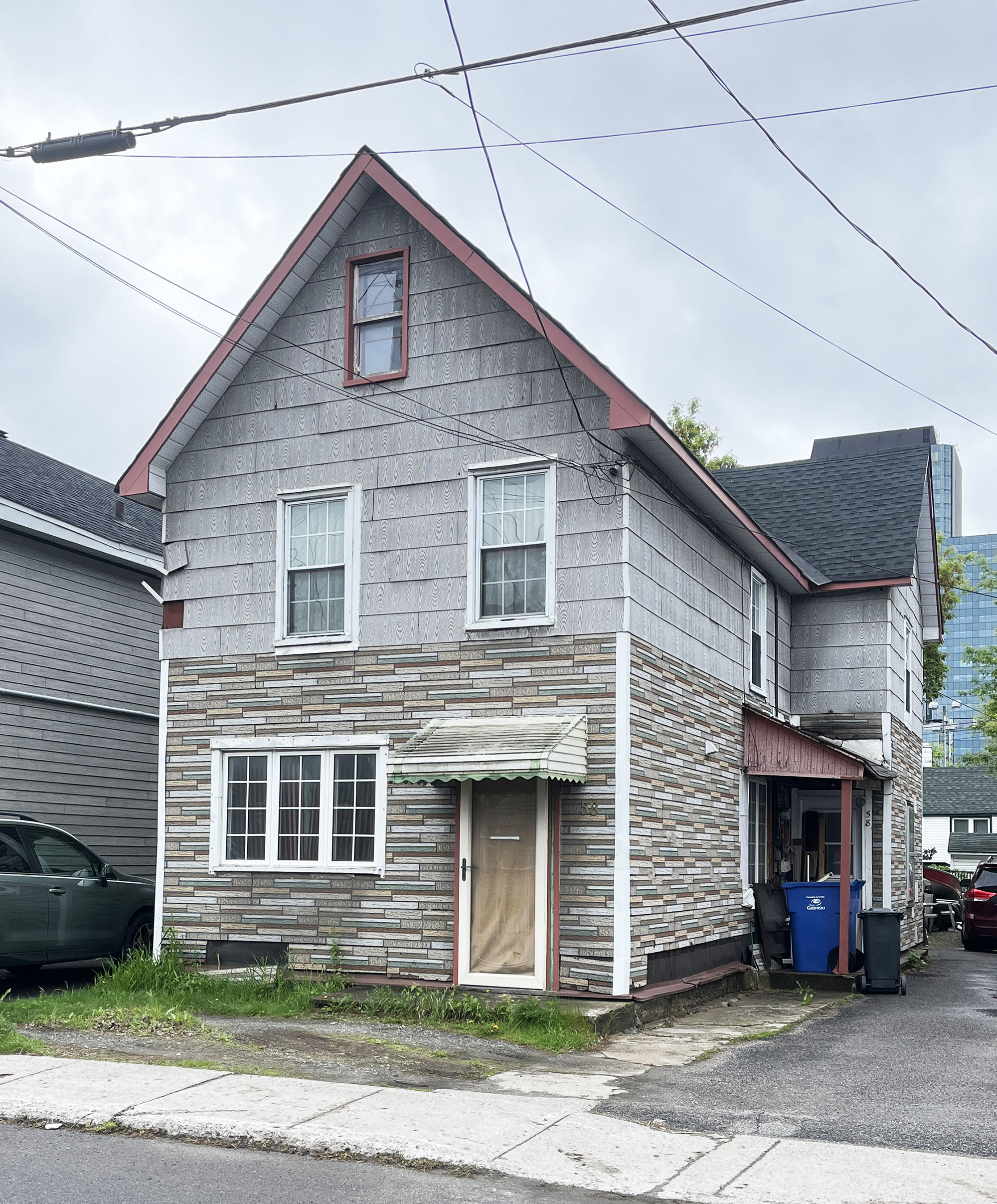
Our final stop brings us a block north where you will find this combo InsulBrick pattern with a stone on the first floor and brick on the top floor.

So there you have it – a tour of some of the few remaining InsulBrick covered houses in the region.
Et voila!